Villey-le-Sec
| Villey-le-Sec | ||
|---|---|---|

|
| |
| Staat | Frankreich | |
| Region | Grand Est | |
| Département (Nr.) | Meurthe-et-Moselle (54) | |
| Arrondissement | Toul | |
| Kanton | Toul | |
| Gemeindeverband | Terres Touloises | |
| Koordinaten | 48° 40′ N, 5° 59′ O | |
| Höhe | 207–340 m | |
| Fläche | 6,41 km² | |
| Einwohner | 415 (1. Januar 2019) | |
| Bevölkerungsdichte | 65 Einw./km² | |
| Postleitzahl | 54840 | |
| INSEE-Code | 54583 | |
| Website | http://www.villey-le-sec.com/ | |
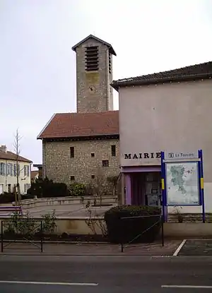 Rathaus und Kirche von Villey-le-Sec | ||

Villey-le-Sec ist eine französische Gemeinde mit 415 Einwohnern (Stand: 1. Januar 2019) im Département Meurthe-et-Moselle in Lothringen in der Region Grand Est. Sie gehört zum Arrondissement Toul sowie zum Kanton Toul (bis 2015: Kanton Toul-Sud). Die Einwohner werden Trabecs genannt.
Geographie
Villey-le-Sec liegt etwa 20 Kilometer westsüdwestlich von Nancy und etwa sechs Kilometer ostsüdöstlich von Toul an der Mosel (frz. Moselle). Nachbargemeinden von Villey-le-Sec sind Gondreville im Norden und Osten, Sexey-aux-Forges im Osten und Südosten, Pierre-la-Treiche im Süden und Südwesten, Chaudeney-sur-Moselle im Westen sowie Dommartin-lès-Toul im Nordwesten.
Bevölkerungsentwicklung
| Jahr | 1962 | 1968 | 1975 | 1982 | 1990 | 1999 | 2006 | 2013 |
| Einwohner | 216 | 162 | 214 | 233 | 239 | 340 | 405 | 413 |
| Quelle: Cassini und INSEE | ||||||||
Sehenswürdigkeiten
- Kirche Mariä Geburt (Nativité-de-la-Vierge), 1955 wieder errichtet
- Festung von Villey-le-Sec
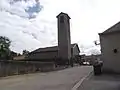 Kirche Mariä Geburt
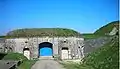 Festung von Villey-le-Sec
This article is issued from Wikipedia. The text is licensed under Creative Commons - Attribution - Sharealike. The authors of the article are listed here. Additional terms may apply for the media files, click on images to show image meta data.