Dommartin-lès-Toul
| Dommartin-lès-Toul | ||
|---|---|---|

|
| |
| Staat | Frankreich | |
| Region | Grand Est | |
| Département (Nr.) | Meurthe-et-Moselle (54) | |
| Arrondissement | Toul | |
| Kanton | Toul | |
| Gemeindeverband | Terres Touloises | |
| Koordinaten | 48° 40′ N, 5° 55′ O | |
| Höhe | 201–295 m | |
| Fläche | 6,84 km² | |
| Einwohner | 1.951 (1. Januar 2019) | |
| Bevölkerungsdichte | 285 Einw./km² | |
| Postleitzahl | 54200 | |
| INSEE-Code | 54167 | |
| Website | http://www.dommartin-les-toul.com/ | |
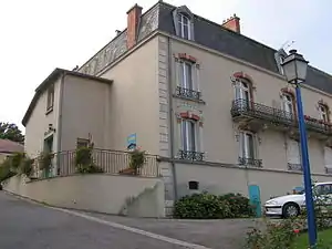 Rathaus von Dommartin-lès-Toul | ||

Dommartin-lès-Toul ist eine französische Gemeinde mit 1.951 Einwohnern (Stand: 1. Januar 2019) im Département Meurthe-et-Moselle in der Region Grand Est (bis 2015 Lothringen). Sie gehört zum Arrondissement Toul und zum Kanton Toul.
Geographie
Dommartin-lès-Toul liegt an der Mosel. Die Nachbargemeinden von Dommartin-lès-Martin sind Toul im Westen und Norden, Gondreville im Osten, Villey-le-Sec im Südosten sowie Chaudeney-sur-Moselle im Süden.
Durch die Gemeinde führt die Autoroute A31.
Geschichte
Während des Zweiten Weltkriegs befand sich hier das Frontstalag 162 (deutsches Kriegsgefangenenlager).
Bevölkerungsentwicklung
| Jahr | 1962 | 1968 | 1975 | 1982 | 1990 | 1999 | 2006 | 2012 | 2019 |
| Einwohner | 1081 | 1004 | 1218 | 1714 | 1639 | 1644 | 1971 | 2001 | 1951 |
Sehenswürdigkeiten
- Kirche Saint-Martin aus dem Jahr 1841
- Altes Schloss der Grafen von Fontenoy
- Reste der gallorömischen Villa
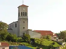
Kirche Saint-Martin
Persönlichkeiten
- Benjamin Jeannot (* 1992), Fußballspieler
This article is issued from Wikipedia. The text is licensed under Creative Commons - Attribution - Sharealike. The authors of the article are listed here. Additional terms may apply for the media files, click on images to show image meta data.