Fontenoy-sur-Moselle
| Fontenoy-sur-Moselle | ||
|---|---|---|

|
| |
| Staat | Frankreich | |
| Region | Grand Est | |
| Département (Nr.) | Meurthe-et-Moselle (54) | |
| Arrondissement | Toul | |
| Kanton | Le Nord-Toulois | |
| Gemeindeverband | Terres Touloises | |
| Koordinaten | 48° 43′ N, 5° 59′ O | |
| Höhe | 192–264 m | |
| Fläche | 5,49 km² | |
| Einwohner | 376 (1. Januar 2019) | |
| Bevölkerungsdichte | 68 Einw./km² | |
| Postleitzahl | 54840 | |
| INSEE-Code | 54202 | |
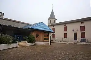 Rathaus (Mairie) von Fontenoy-sur-Moselle | ||

Fontenoy-sur-Moselle ist eine französische Gemeinde mit 376 Einwohnern (Stand: 1. Januar 2019) im Département Meurthe-et-Moselle in der Region Grand Est (vor 2016 Lothringen). Sie gehört zum Arrondissement Toul und zum Kanton Le Nord-Toulois.
Geografie
Fontenoy-sur-Moselle liegt etwa 19 Kilometer westnordwestlich von Nancy an der Mosel. Nachbargemeinden sind Villey-Saint-Étienne im Westen und Norden, Aingeray im Norden und Nordosten, Bois-de-Haye im Nordosten und Osten sowie Gondreville im Süden und Westen.
Bevölkerungsentwicklung
| Jahr | 1962 | 1968 | 1975 | 1982 | 1990 | 1999 | 2006 | 2019 |
| Einwohner | 234 | 206 | 219 | 229 | 224 | 195 | 350 | 376 |
| Quellen: Cassini und INSEE | ||||||||
Sehenswürdigkeiten
- Kirche Saint-Laurent
- Festung aus dem 13. Jahrhundert
- Brücke über die Mosel
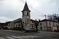 Kirche Saint-Laurent
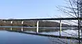 Brücke über die Mosel
This article is issued from Wikipedia. The text is licensed under Creative Commons - Attribution - Sharealike. The authors of the article are listed here. Additional terms may apply for the media files, click on images to show image meta data.