Vernais
Vernais ist eine französische Gemeinde mit 189 Einwohnern (Stand: 1. Januar 2019) im Département Cher in der Region Centre-Val de Loire; sie gehört zum Arrondissement Saint-Amand-Montrond und zum Kanton Dun-sur-Auron (bis 2015: Kanton Charenton-du-Cher).
| Vernais | ||
|---|---|---|
| ||
| Staat | Frankreich | |
| Region | Centre-Val de Loire | |
| Département (Nr.) | Cher (18) | |
| Arrondissement | Saint-Amand-Montrond | |
| Kanton | Dun-sur-Auron | |
| Gemeindeverband | Cœur de France | |
| Koordinaten | 46° 46′ N, 2° 43′ O | |
| Höhe | 170–222 m | |
| Fläche | 26,29 km² | |
| Einwohner | 189 (1. Januar 2019) | |
| Bevölkerungsdichte | 7 Einw./km² | |
| Postleitzahl | 18210 | |
| INSEE-Code | 18276 | |
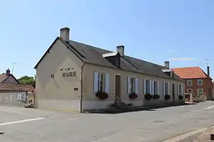 Rathaus (Mairie) von Vernais | ||

Geografie
Vernais liegt etwa 44 Kilometer südsüdöstlich von Bourges am Canal du Berry. Umgeben wird Vernais von den Nachbargemeinden Bannegon im Norden und Nordosten, Bessais-le-Fromental im Osten und Südosten, Ainay-le-Château im Süden, Charenton-du-Cher im Westen sowie Thaumiers im Nordwesten.
Bevölkerungsentwicklung
| Jahr | 1962 | 1968 | 1975 | 1982 | 1990 | 1999 | 2006 | 2013 |
| Einwohner | 301 | 294 | 296 | 280 | 255 | 232 | 222 | 213 |
| Quelle: Cassini und INSEE | ||||||||
Sehenswürdigkeiten
- Kirche Notre-Dame aus dem 12. Jahrhundert (siehe auch: Liste der Monuments historiques in Vernais)

Kirche Notre-Dame
Literatur
- Le Patrimoine des Communes du Cher. Flohic Editions, Band 1, Paris 2001, ISBN 2-84234-088-4, S. 273–275.
Weblinks
Commons: Vernais – Sammlung von Bildern, Videos und Audiodateien
This article is issued from Wikipedia. The text is licensed under Creative Commons - Attribution - Sharealike. The authors of the article are listed here. Additional terms may apply for the media files, click on images to show image meta data.