Marçais
Marçais ist eine französische Gemeinde mit 296 Einwohnern (Stand: 1. Januar 2019) im Département Cher in der Region Centre-Val de Loire; sie gehört zum Arrondissement Saint-Amand-Montrond und zum Kanton Saint-Amand-Montrond.
| Marçais | ||
|---|---|---|
| ||
| Staat | Frankreich | |
| Region | Centre-Val de Loire | |
| Département (Nr.) | Cher (18) | |
| Arrondissement | Saint-Amand-Montrond | |
| Kanton | Saint-Amand-Montrond | |
| Gemeindeverband | Cœur de France | |
| Koordinaten | 46° 42′ N, 2° 22′ O | |
| Höhe | 177–241 m | |
| Fläche | 29,28 km² | |
| Einwohner | 296 (1. Januar 2019) | |
| Bevölkerungsdichte | 10 Einw./km² | |
| Postleitzahl | 18170 | |
| INSEE-Code | 18136 | |
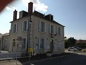 Rathaus von Marçais | ||

Geographie
Marçais liegt etwa 41 Kilometer südlich von Bourges. Umgeben wird Marçais von den Nachbargemeinden Morlac im Norden und Westen, Vallenay im Nordosten, Orcenais im Osten, Arcomps und Loye-sur-Arnon im Südosten, Ardenais im Süden sowie Saint-Pierre-les-Bois im Südwesten.
Bevölkerungsentwicklung
| 1962 | 1968 | 1975 | 1982 | 1990 | 1999 | 2006 | 2013 |
|---|---|---|---|---|---|---|---|
| 531 | 484 | 424 | 372 | 371 | 324 | 306 | 311 |
| Quelle: Cassini und INSEE | |||||||
Sehenswürdigkeiten
- Kirche Saint-Maurice aus dem 12./13. Jahrhundert
- Schloss La Mothe aus dem 15. Jahrhundert
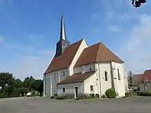
Kirche Saint-Maurice
Literatur
- Le Patrimoine des Communes du Cher. Flohic Editions, Band 2, Paris 2001, ISBN 2-84234-088-4, S. 734–736.
This article is issued from Wikipedia. The text is licensed under Creative Commons - Attribution - Sharealike. The authors of the article are listed here. Additional terms may apply for the media files, click on images to show image meta data.