Grossouvre
| Grossouvre | ||
|---|---|---|
.svg.png.webp)
|
| |
| Staat | Frankreich | |
| Region | Centre-Val de Loire | |
| Département (Nr.) | Cher (18) | |
| Arrondissement | Saint-Amand-Montrond | |
| Kanton | Dun-sur-Auron | |
| Gemeindeverband | Les Trois Provinces | |
| Koordinaten | 46° 53′ N, 2° 56′ O | |
| Höhe | 182–230 m | |
| Fläche | 15,86 km² | |
| Einwohner | 266 (1. Januar 2019) | |
| Bevölkerungsdichte | 17 Einw./km² | |
| Postleitzahl | 18600 | |
| INSEE-Code | 18106 | |
| Website | http://grossouvre.site.voila.fr/ | |

Grossouvre ist eine französische Gemeinde mit 266 Einwohnern (Stand: 1. Januar 2019) im Département Cher in der Region Centre-Val de Loire; sie gehört zum Arrondissement Saint-Amand-Montrond und zum Kanton Dun-sur-Auron (bis 2015: Kanton Sancoins). Die Einwohner werden Grossouvrois genannt.
Geografie
Grossouvre liegt etwa 50 Kilometer südöstlich von Bourges am Canal du Berry. Umgeben wird Grossouvre von den Nachbargemeinden La Chapelle-Hugon im Norden und Nordosten, Neuvy-le-Barrois im Osten, Sancoins im Süden, Vereaux im Westen sowie Germigny-l’Exempt im Nordwesten.
Bevölkerungsentwicklung
| Jahr | 1962 | 1968 | 1975 | 1982 | 1990 | 1999 | 2006 | 2013 |
| Einwohner | 470 | 420 | 400 | 331 | 254 | 238 | 277 | 288 |
| Quelle: Cassini und INSEE | ||||||||
Sehenswürdigkeiten
- Kirche Notre-Dame-du-Mont-Carmel
- Burg Grossouvre aus dem 13. Jahrhundert, Umbauten aus dem 15. Jahrhundert
- Hüttenmuseum
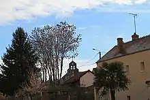
Blick auf die Kirche Notre-Dame-du-Mont-Carmel
Literatur
- Le Patrimoine des Communes du Cher. Flohic Editions, Band 2, Paris 2001, ISBN 2-84234-088-4, S. 923–925.
Weblinks
Commons: Grossouvre – Sammlung von Bildern, Videos und Audiodateien
This article is issued from Wikipedia. The text is licensed under Creative Commons - Attribution - Sharealike. The authors of the article are listed here. Additional terms may apply for the media files, click on images to show image meta data.