La Celette
La Celette ist eine französische Gemeinde mit 192 Einwohnern (Stand: 1. Januar 2019) im Département Cher in der Region Centre-Val de Loire; sie gehört zum Arrondissement Saint-Amand-Montrond und zum Kanton Châteaumeillant (bis 2015: Kanton Saulzais-le-Potier).
| La Celette | ||
|---|---|---|
| ||
| Staat | Frankreich | |
| Region | Centre-Val de Loire | |
| Département (Nr.) | Cher (18) | |
| Arrondissement | Saint-Amand-Montrond | |
| Kanton | Châteaumeillant | |
| Gemeindeverband | Berry Grand Sud | |
| Koordinaten | 46° 39′ N, 2° 31′ O | |
| Höhe | 165–231 m | |
| Fläche | 25,24 km² | |
| Einwohner | 192 (1. Januar 2019) | |
| Bevölkerungsdichte | 8 Einw./km² | |
| Postleitzahl | 18360 | |
| INSEE-Code | 18041 | |
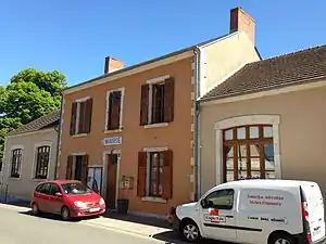 Rathaus (Mairie) von La Celette | ||

Geographie
La Celette liegt etwa 47 Kilometer südsüdöstlich von Bourges. Umgeben wird La Celette von den Nachbargemeinden Saint-Georges-de-Poisieux im Norden und Nordwesten, Ainay-le-Vieil im Osten und Nordosten, La Perche im Osten und Südosten, Épineuil-le-Fleuriel im Süden und Südosten, Saulzais-le-Potier im Süden und Südwesten sowie Faverdines im Westen.
Bevölkerungsentwicklung
| Jahr | 1962 | 1968 | 1975 | 1982 | 1990 | 1999 | 2006 | 2013 |
| Einwohner | 338 | 305 | 221 | 200 | 180 | 181 | 217 | 178 |
| Quelle: Cassini und INSEE | ||||||||
Sehenswürdigkeiten
- Kirche Saint-Paul (vor dem 19. Jahrhundert: Saint-Pierre) aus dem 12. Jahrhundert
- Pfarrhaus
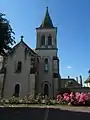 Kirche Saint-Paul
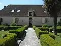 Pfarrhaus
Literatur
- Le Patrimoine des Communes du Cher. Flohic Editions, Band 2, Paris 2001, ISBN 2-84234-088-4, S. 968.
Weblinks
Commons: La Celette – Sammlung von Bildern, Videos und Audiodateien
This article is issued from Wikipedia. The text is licensed under Creative Commons - Attribution - Sharealike. The authors of the article are listed here. Additional terms may apply for the media files, click on images to show image meta data.