Charly (Cher)
Charly ist eine französische Gemeinde mit 246 Einwohnern (Stand: 1. Januar 2019) im Département Cher in der Region Centre-Val de Loire; sie gehört zum Arrondissement Saint-Amand-Montrond und ist Teil des Kantons La Guerche-sur-l’Aubois (bis 2015: Kanton Nérondes). Die Einwohner werden Charliacois genannt.
| Charly | ||
|---|---|---|
| ||
| Staat | Frankreich | |
| Region | Centre-Val de Loire | |
| Département (Nr.) | Cher (18) | |
| Arrondissement | Saint-Amand-Montrond | |
| Kanton | La Guerche-sur-l’Aubois | |
| Gemeindeverband | Pays de Nérondes | |
| Koordinaten | 46° 54′ N, 2° 45′ O | |
| Höhe | 169–256 m | |
| Fläche | 26,02 km² | |
| Einwohner | 246 (1. Januar 2019) | |
| Bevölkerungsdichte | 9 Einw./km² | |
| Postleitzahl | 18320 | |
| INSEE-Code | 18054 | |

Geographie
Charly liegt etwa drei Kilometer ostsüdöstlich von Bourges. Umgeben wird Charly von den Nachbargemeinden Cornusse im Norden und Nordwesten, Ourouer-les-Bourdelins im Norden und Osten, Vereaux und Sagonne im Südosten, Blet im Süden und Westen sowie Lugny-Bourbonnais im Nordwesten.
Bevölkerungsentwicklung
| Jahr | 1962 | 1968 | 1975 | 1982 | 1990 | 1999 | 2006 | 2013 |
|---|---|---|---|---|---|---|---|---|
| Einwohner | 399 | 364 | 273 | 272 | 252 | 257 | 233 | 252 |
| Quelle: Cassini und INSEE | ||||||||
Sehenswürdigkeiten
- Kirche Notre-Dame aus dem 12. Jahrhundert, seit 1862 Monument historique
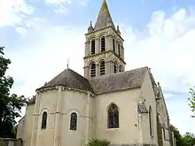
Kirche Notre-Dame
Literatur
- Le Patrimoine des Communes du Cher. Flohic Editions, Band 2, Paris 2001, ISBN 2-84234-088-4, S. 691–693.
Weblinks
Commons: Charly – Sammlung von Bildern, Videos und Audiodateien
This article is issued from Wikipedia. The text is licensed under Creative Commons - Attribution - Sharealike. The authors of the article are listed here. Additional terms may apply for the media files, click on images to show image meta data.