Saint-Vérand (Rhône)
Saint-Vérand ist eine französische Gemeinde mit 1.212 Einwohnern (Stand: 1. Januar 2019) im Département Rhône in der Region Auvergne-Rhône-Alpes. Sie gehört zum Arrondissement Villefranche-sur-Saône, zum Kanton Val d’Oingt und ist Mitglied im Gemeindeverband Beaujolais Pierres Dorées. Die Einwohner werden Véranais genannt.
| Saint-Vérand | ||
|---|---|---|
.svg.png.webp)
|
| |
| Staat | Frankreich | |
| Region | Auvergne-Rhône-Alpes | |
| Département (Nr.) | Rhône (69) | |
| Arrondissement | Villefranche-sur-Saône | |
| Kanton | Val d’Oingt | |
| Gemeindeverband | Beaujolais Pierres Dorées | |
| Koordinaten | 45° 55′ N, 4° 32′ O | |
| Höhe | 258–686 m | |
| Fläche | 17,48 km² | |
| Einwohner | 1.212 (1. Januar 2019) | |
| Bevölkerungsdichte | 69 Einw./km² | |
| Postleitzahl | 69620 | |
| INSEE-Code | 69239 | |

Geographie
Saint-Vérand liegt rund 29 Kilometer nordwestlich von Lyon und etwa 16 Kilometer südsüdwestlich von Villefranche-sur-Saône im Weinbaugebiet Bourgogne. Umgeben wird Saint-Vérand von den Nachbargemeinden
- Ternand im Norden,
- Saint-Laurent-d’Oingt im Nordosten,
- Le Bois-d’Oingt im Osten,
- Légny im Südosten,
- Sarcey im Süden und Südosten,
- Vindry-sur-Turdine mit Saint-Loup und Dareizé im Süden und Südwesten,
- Saint-Clément-sur-Valsonne im Westen,
- Dième im Nordwesten.
Bevölkerungsentwicklung
| Jahr | 1962 | 1968 | 1975 | 1982 | 1990 | 1999 | 2006 | 2012 |
| Einwohner | 647 | 610 | 636 | 713 | 760 | 993 | 1.082 | 1.113 |
| Quellen: Cassini und INSEE | ||||||||
Sehenswürdigkeiten
- Kirche Saint-Vérand
- Schloss La Flachère
- Schloss La Garde
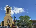 Kirche Saint-Vérand
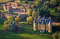 Schloss La Flachère
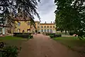 Schloss La Garde
Weblinks
Commons: Saint-Vérand – Sammlung von Bildern, Videos und Audiodateien
This article is issued from Wikipedia. The text is licensed under Creative Commons - Attribution - Sharealike. The authors of the article are listed here. Additional terms may apply for the media files, click on images to show image meta data.