Saint-Igny-de-Vers
| Saint-Igny-de-Vers | ||
|---|---|---|
|
| |
| Staat | Frankreich | |
| Region | Auvergne-Rhône-Alpes | |
| Département (Nr.) | Rhône (69) | |
| Arrondissement | Villefranche-sur-Saône | |
| Kanton | Thizy-les-Bourgs | |
| Gemeindeverband | Saône-Beaujolais | |
| Koordinaten | 46° 14′ N, 4° 26′ O | |
| Höhe | 407–943 m | |
| Fläche | 27,14 km² | |
| Einwohner | 566 (1. Januar 2019) | |
| Bevölkerungsdichte | 21 Einw./km² | |
| Postleitzahl | 69790 | |
| INSEE-Code | 69209 | |
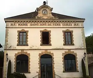 Rathaus (Mairie) von Saint-Igny-de-Vers | ||

Saint-Igny-de-Vers ist eine französische Gemeinde mit 566 Einwohnern (Stand: 1. Januar 2019) im Département Rhône in der Region Auvergne-Rhône-Alpes. Sie gehört zum Arrondissement Villefranche-sur-Saône und zum Kanton Thizy-les-Bourgs (bis 2015: Kanton Monsols). Die Einwohner werden Saint-Ignons genannt.
Geographie
Saint-Igny-de-Vers liegt rund 61 Kilometer nordnordwestlich von Lyon und etwa 35 Kilometer nordnordwestlich von Villefranche-sur-Saône. Umgeben wird Saint-Igny-de-Vers von den Nachbargemeinden Aigueperse im Norden und Nordwesten, Saint-Bonnet-des-Bruyères im Norden und Nordosten, Deux-Grosnes mit Monsols im Osten, Propières im Süden und Westen sowie Saint-Racho im Westen und Nordwesten.
Bevölkerungsentwicklung
| Jahr | 1962 | 1968 | 1975 | 1982 | 1990 | 1999 | 2006 | 2013 |
| Einwohner | 828 | 759 | 729 | 598 | 503 | 553 | 592 | 600 |
| Quellen: Cassini und INSEE | ||||||||
Sehenswürdigkeiten
- Kirche Saint-Jean-Baptiste
- Kapelle Notre-Dame
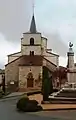 Kirche Saint-Jean-Baptiste und Gefallenendenkmal
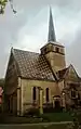 Kapelle Notre-Dame
Weblinks
Commons: Saint-Igny-de-Vers – Sammlung von Bildern, Videos und Audiodateien
This article is issued from Wikipedia. The text is licensed under Creative Commons - Attribution - Sharealike. The authors of the article are listed here. Additional terms may apply for the media files, click on images to show image meta data.