Kanton Val d’Oingt
Der Kanton Val d’Oingt (früher Le Bois-d’Oingt) ist ein französischer Wahlkreis im Département Rhône in der Region Auvergne-Rhône-Alpes. Er umfasst 23 Gemeinden im Arrondissement Villefranche-sur-Saône und hat seinen Hauptort (frz.: bureau centralisateur) in Val d’Oingt. Durch die landesweite Neuordnung der französischen Kantone wurde er 2015 vergrößert.
| Kanton Val d’Oingt | |
|---|---|
| Region | Auvergne-Rhône-Alpes |
| Département | Rhône |
| Arrondissement | Villefranche-sur-Saône |
| Hauptort | Val d’Oingt |
| Einwohner | 29.602 (1. Jan. 2019) |
| Bevölkerungsdichte | 148 Einw./km² |
| Fläche | 199,53 km² |
| Gemeinden | 23 |
| INSEE-Code | 6904 |
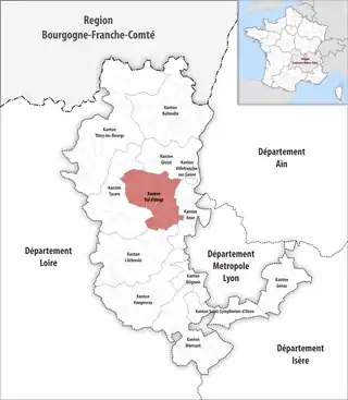 Lage des Kantons Val d’Oingt im Département Rhône | |
Gemeinden
Der Kanton besteht aus 23 Gemeinden mit insgesamt 29.602 Einwohnern (Stand: 2019) auf einer Gesamtfläche von 199,53 km²:
| Gemeinde | Einwohner 1. Januar 2019 |
Fläche km² |
Dichte Einw./km² |
Code INSEE |
Postleitzahl |
|---|---|---|---|---|---|
| Alix | 768 | 3,61 | 213 | 69004 | 69380 |
| Bagnols | 745 | 7,48 | 100 | 69017 | 69620 |
| Belmont-d’Azergues | 681 | 1,55 | 439 | 69020 | 69380 |
| Bully | 1.988 | 12,75 | 156 | 69032 | 69210 |
| Chamelet | 694 | 14,73 | 47 | 69039 | 69620 |
| Charnay | 1.051 | 7,29 | 144 | 69047 | 69380 |
| Châtillon | 2.113 | 10,78 | 196 | 69050 | 69380 |
| Chessy | 2.107 | 4,52 | 466 | 69056 | 69380 |
| Cogny | 1.188 | 5,80 | 205 | 69061 | 69640 |
| Frontenas | 809 | 3,51 | 230 | 69090 | 69620 |
| Le Breuil | 548 | 5,65 | 97 | 69026 | 69620 |
| Légny | 673 | 4,07 | 165 | 69111 | 69620 |
| Létra | 901 | 14,70 | 61 | 69113 | 69620 |
| Moiré | 227 | 2,03 | 112 | 69134 | 69620 |
| Porte des Pierres Dorées | 3.907 | 13,52 | 289 | 69159 | 69400, 69640 |
| Sainte-Paule | 320 | 7,67 | 42 | 69230 | 69620 |
| Saint-Germain-Nuelles | 2.262 | 8,65 | 262 | 69208 | 69210 |
| Saint-Jean-des-Vignes | 479 | 2,58 | 186 | 69212 | 69380 |
| Saint-Vérand | 1.212 | 17,48 | 69 | 69239 | 69620 |
| Ternand | 710 | 10,74 | 66 | 69245 | 69620 |
| Theizé | 1.295 | 11,89 | 109 | 69246 | 69620 |
| Val d’Oingt | 4.122 | 18,26 | 226 | 69024 | 69620 |
| Ville-sur-Jarnioux | 802 | 10,27 | 78 | 69265 | 69640 |
| Kanton Val d’Oingt | 29.602 | 199,53 | 148 | 6904 | – |
Bis zur Neuordnung gehörten zum Kanton Val d’Oingt die 18 Gemeinden Bagnols, Chamelet, Chessy, Châtillon, Frontenas, Jarnioux, Le Bois-d’Oingt, Le Breuil, Légny, Létra, Moiré, Oingt, Saint-Laurent-d’Oingt, Saint-Vérand, Sainte-Paule, Ternand, Theizé und Ville-sur-Jarnioux. Sein Zuschnitt entsprach einer Fläche von 146,86 km2. Er besaß vor 2015 einen anderen INSEE-Code als heute, nämlich 6906.
Mit Wirkung vom 1. Januar 2013 wurden die früheren Gemeinden Nuelles und Saint-Germain-sur-l’Arbresle, damals noch im Kanton L’Arbresle, zur Gemeinde Saint-Germain-Nuelles zusammengelegt.
Veränderungen im Gemeindebestand seit der landesweiten Neuordnung der Kantone
2019:
- Fusion Jarnioux und Porte des Pierres Dorées → Porte des Pierres Dorées
2017:
- Fusion Liergues und Pouilly-le-Monial → Porte des Pierres Dorées
- Fusion Le Bois-d’Oingt, Oingt und Saint-Laurent-d’Oingt → Val d’Oingt
Politik
| Vertreter im Départementsrat | ||
|---|---|---|
| Amtszeit | Namen | Partei |
| 1998–2015 | Charles Bréchard | UDF |
| 2015– | Antoine Duperray Martine Publié | Les Républicains |