Saint-Aubin-de-Crétot
Saint-Aubin-de-Crétot ist eine französische Gemeinde mit 512 Einwohnern (Stand: 1. Januar 2019) im Département Seine-Maritime in der Region Normandie. Die Gemeinde gehört zum Arrondissement Rouen und zum Kanton Port-Jérôme-sur-Seine (bis 2015: Kanton Caudebec-en-Caux). Die Einwohner werden Saint-Aubinois genannt.
| Saint-Aubin-de-Crétot | ||
|---|---|---|

|
| |
| Staat | Frankreich | |
| Region | Normandie | |
| Département (Nr.) | Seine-Maritime (76) | |
| Arrondissement | Rouen | |
| Kanton | Port-Jérôme-sur-Seine | |
| Gemeindeverband | Caux Seine Agglo | |
| Koordinaten | 49° 34′ N, 0° 38′ O | |
| Höhe | 80–154 m | |
| Fläche | 4,77 km² | |
| Einwohner | 512 (1. Januar 2019) | |
| Bevölkerungsdichte | 107 Einw./km² | |
| Postleitzahl | 76190 | |
| INSEE-Code | 76559 | |
| Website | https://saint-aubin-de-cretot.fr/ | |

Geografie
Saint-Aubin-de-Crétot ist eine Landgemeinde im Pays de Caux und liegt etwa 32 Kilometer ostnordöstlich von Le Havre. Umgeben wird Saint-Aubin-de-Crétot von den Nachbargemeinden Allouville-Bellefosse im Norden und Nordosten, Bois-Himont im Nordosten, Saint-Gilles-de-Crétot im Süden und Osten, Saint-Nicolas-de-la-Haie im Süden und Südwesten sowie Trouville im Westen und Nordwesten.
| Bevölkerungsentwicklung | ||||||||
|---|---|---|---|---|---|---|---|---|
| Jahr | 1962 | 1968 | 1975 | 1982 | 1990 | 1999 | 2006 | 2013 |
| Einwohner | 229 | 209 | 211 | 374 | 465 | 474 | 511 | 575 |
| Quelle: Cassini und INSEE | ||||||||
Sehenswürdigkeiten
- Kirche Saint-Aubin aus dem 12. Jahrhundert, seit 1926 Monument historique
- Schloss Saint-Aubin-de-Crétot aus dem 17. Jahrhundert
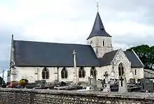
Kirche Saint-Aubin
This article is issued from Wikipedia. The text is licensed under Creative Commons - Attribution - Sharealike. The authors of the article are listed here. Additional terms may apply for the media files, click on images to show image meta data.