Notre-Dame-de-Bliquetuit
Notre-Dame-de-Bliquetuit ist eine französische Gemeinde mit 790 Einwohnern (Stand: 1. Januar 2019) im Département Seine-Maritime in der Region Normandie. Sie gehört zum Arrondissement Rouen und zum Kanton Port-Jérôme-sur-Seine (bis 2015: Kanton Caudebec-en-Caux).
| Notre-Dame-de-Bliquetuit | ||
|---|---|---|
| ||
| Staat | Frankreich | |
| Region | Normandie | |
| Département (Nr.) | Seine-Maritime (76) | |
| Arrondissement | Rouen | |
| Kanton | Port-Jérôme-sur-Seine | |
| Gemeindeverband | Caux Seine Agglo | |
| Koordinaten | 49° 30′ N, 0° 46′ O | |
| Höhe | 1–53 m | |
| Fläche | 10,00 km² | |
| Einwohner | 790 (1. Januar 2019) | |
| Bevölkerungsdichte | 79 Einw./km² | |
| Postleitzahl | 76940 | |
| INSEE-Code | 76473 | |
| Website | http://www.notre-dame-de-bliquetuit.com/ | |

Geographie
Notre-Dame-de-Bliquetuit liegt etwa 24 Kilometer westnordwestlich von Rouen im Regionalen Naturpark Boucles de la Seine Normande an der Seine. Umgeben wird Notre-Dame-de-Bliquetuit von den Nachbargemeinden Saint-Wandrille-Rançon im Norden und Osten, La Mailleraye-sur-Seine im Süden sowie Saint-Nicolas-de-Bliquetuit im Westen.
Einwohnerentwicklung
| 1962 | 1968 | 1975 | 1982 | 1990 | 1999 | 2006 | 2013 | |
|---|---|---|---|---|---|---|---|---|
| 386 | 393 | 413 | 469 | 504 | 559 | 628 | 741 | |
| Quelle: Cassini und INSEE | ||||||||
Sehenswürdigkeiten
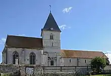
Kirche Notre-Dame
- Kirche Notre-Dame, seit 1923 Monument historique
- Brücke von Brotonne
This article is issued from Wikipedia. The text is licensed under Creative Commons - Attribution - Sharealike. The authors of the article are listed here. Additional terms may apply for the media files, click on images to show image meta data.