Écretteville-lès-Baons
| Écretteville-lès-Baons | ||
|---|---|---|
.svg.png.webp)
|
| |
| Staat | Frankreich | |
| Region | Normandie | |
| Département (Nr.) | Seine-Maritime (76) | |
| Arrondissement | Rouen | |
| Kanton | Yvetot | |
| Gemeindeverband | Région d’Yvetot | |
| Koordinaten | 49° 38′ N, 0° 41′ O | |
| Höhe | 107–139 m | |
| Fläche | 9,37 km² | |
| Einwohner | 377 (1. Januar 2019) | |
| Bevölkerungsdichte | 40 Einw./km² | |
| Postleitzahl | 76190 | |
| INSEE-Code | 76225 | |

Écretteville-lès-Baons ist eine französische Gemeinde mit 377 Einwohnern (Stand: 1. Januar 2019) im Département Seine-Maritime der Region Normandie. Die Gemeinde gehört zum Arrondissement Rouen und ist Teil des Kantons Yvetot. Die Einwohner werden Écrettevillais genannt.
Geografie
Écretteville-lès-Baons liegt etwa 28 Kilometer ostnordöstlich von Le Havre und etwa 32 Kilometer nordwestlich von Rouen inmitten der Landschaft Pays de Caux. Die Nachbargemeinden von Écretteville-lès-Baons sind Envronville im Norden, Hautot-le-Vatois im Nordosten, Valliquerville im Süden und Osten, Allouville-Bellefosse im Süden, Alvimare im Südwesten, Cléville im Westen sowie Terres-de-Caux im Westen und Nordwesten.
Durch die Gemeinde führt die Autoroute A29.
Bevölkerungsentwicklung
| Jahr | 1962 | 1968 | 1975 | 1982 | 1990 | 1999 | 2006 | 2013 |
| Einwohner | 350 | 354 | 381 | 376 | 398 | 420 | 421 | 385 |
| Quelle: Cassini und INSEE | ||||||||
Sehenswürdigkeiten
- Kirche Saint-Blaise aus dem 13. Jahrhundert
- Herrenhaus von Le Catel aus dem 13. Jahrhundert, Monument historique
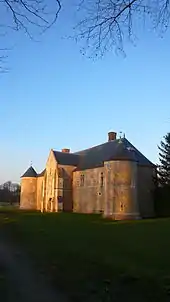
Herrenhaus Le Catel
This article is issued from Wikipedia. The text is licensed under Creative Commons - Attribution - Sharealike. The authors of the article are listed here. Additional terms may apply for the media files, click on images to show image meta data.