Heurteauville
Heurteauville ist eine französische Gemeinde mit 299 Einwohnern (Stand: 1. Januar 2019) im Département Seine-Maritime in der Region Normandie. Heurteauville gehört zum Arrondissement Rouen und ist Teil des Kantons Port-Jérôme-sur-Seine (bis 2015: Kanton Caudebec-en-Caux).
| Heurteauville | ||
|---|---|---|
.svg.png.webp)
|
| |
| Staat | Frankreich | |
| Region | Normandie | |
| Département (Nr.) | Seine-Maritime (76) | |
| Arrondissement | Rouen | |
| Kanton | Port-Jérôme-sur-Seine | |
| Gemeindeverband | Caux Seine Agglo | |
| Koordinaten | 49° 27′ N, 0° 49′ O | |
| Höhe | 0–80 m | |
| Fläche | 7,37 km² | |
| Einwohner | 299 (1. Januar 2019) | |
| Bevölkerungsdichte | 41 Einw./km² | |
| Postleitzahl | 76940 | |
| INSEE-Code | 76362 | |
| Website | https://www.heurteauville.fr/ | |
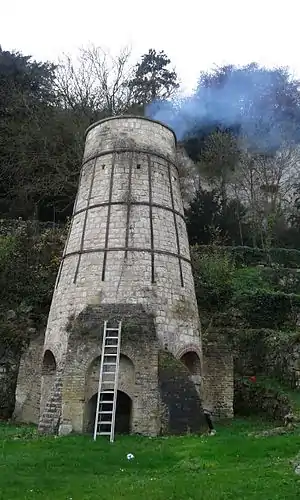
 Kalkofen in Heurteauville | ||
Geographie
Heurteauville liegt in einer Mäander der Seine, etwa 19 Kilometer westlich von Rouen. Alte Torfmoore und ein Wald sind als Naturschutzgebiet gekennzeichnet. Die Gemeinde gehört zum Regionalen Naturpark Boucles de la Seine Normande.
Bevölkerungsentwicklung
| 1962 | 1968 | 1975 | 1982 | 1990 | 1999 | 2006 | 2013 |
|---|---|---|---|---|---|---|---|
| 377 | 309 | 288 | 286 | 269 | 304 | 308 | 337 |
| Quelle: Cassini und INSEE | |||||||
Sehenswürdigkeiten
This article is issued from Wikipedia. The text is licensed under Creative Commons - Attribution - Sharealike. The authors of the article are listed here. Additional terms may apply for the media files, click on images to show image meta data.
