Ancretiéville-Saint-Victor
Ancretiéville-Saint-Victor ist eine französische Gemeinde mit 373 Einwohnern (Stand: 1. Januar 2019) im Département Seine-Maritime in der Region Normandie. Ancretiéville-Saint-Victor gehört zum Arrondissement Rouen und ist Teil des Kantons Yvetot (bis 2015: Kanton Yerville).
| Ancretiéville-Saint-Victor | ||
|---|---|---|
.svg.png.webp)
|
| |
| Staat | Frankreich | |
| Region | Normandie | |
| Département (Nr.) | Seine-Maritime (76) | |
| Arrondissement | Rouen | |
| Kanton | Yvetot | |
| Gemeindeverband | Plateau de Caux-Doudeville-Yerville | |
| Koordinaten | 49° 39′ N, 0° 58′ O | |
| Höhe | 114–172 m | |
| Fläche | 11,64 km² | |
| Einwohner | 373 (1. Januar 2019) | |
| Bevölkerungsdichte | 32 Einw./km² | |
| Postleitzahl | 76760 | |
| INSEE-Code | 76010 | |

Geographie
Ancretiélle-Saint-Victor liegt etwa 25 Kilometer nordnordwestlich von Rouen. Die Autoroute A29 verläuft in der Nähe von Ancretiéville-Saint-Victor.
Einwohnerentwicklung
| 1962 | 1968 | 1975 | 1982 | 1990 | 1999 | 2006 | 2013 |
|---|---|---|---|---|---|---|---|
| 243 | 267 | 219 | 277 | 262 | 272 | 338 | 383 |
| Quelle: Cassini und INSEE | |||||||
Sehenswürdigkeiten
- Kirche St. Victor aus dem 19. Jahrhundert
- Kirche St. Peter aus dem 11. Jahrhundert
- Burg und Park von St. Victor aus dem 18. Jahrhundert
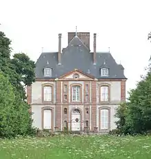
Schloss Saint-Victor
This article is issued from Wikipedia. The text is licensed under Creative Commons - Attribution - Sharealike. The authors of the article are listed here. Additional terms may apply for the media files, click on images to show image meta data.