Le Doulieu
Le Doulieu (niederländisch Zouterstee) ist eine französische Gemeinde mit 1466 Einwohnern (Stand 1. Januar 2019) im Département Nord in der Region Hauts-de-France. Sie gehört zum Arrondissement Dunkerque und zum Kanton Bailleul.
| Le Doulieu | ||
|---|---|---|
_Nord-France.svg.png.webp)
|
| |
| Staat | Frankreich | |
| Region | Hauts-de-France | |
| Département (Nr.) | Nord (59) | |
| Arrondissement | Dunkerque | |
| Kanton | Bailleul | |
| Gemeindeverband | Flandre Intérieure | |
| Koordinaten | 50° 41′ N, 2° 43′ O | |
| Höhe | 15–19 m | |
| Fläche | 11,88 km² | |
| Einwohner | 1.466 (1. Januar 2019) | |
| Bevölkerungsdichte | 123 Einw./km² | |
| Postleitzahl | 59940 | |
| INSEE-Code | 59180 | |
| Website | http://ledoulieu.fr | |
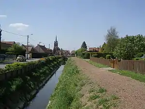 Blick auf Le Doulieu | ||

Nachbargemeinden von Le Doulieu sind Bailleul im Norden, Steenwerck im Nordosten, Estaires im Südosten, Neuf-Berquin im Südwesten und Vieux-Berquin im Westen.
Bevölkerungsentwicklung
| Jahr | 1962 | 1968 | 1975 | 1982 | 1990 | 1999 | 2007 |
| Einwohner | 789 | 727 | 714 | 965 | 1.138 | 1.227 | 1.398 |
Bodendenkmäler
Literatur
- Le Patrimoine des Communes du Nord. Flohic Editions, Band 2, Paris 2001, ISBN 2-84234-119-8, S. 1255–1256.
Weblinks
Commons: Le Doulieu – Sammlung von Bildern, Videos und Audiodateien
This article is issued from Wikipedia. The text is licensed under Creative Commons - Attribution - Sharealike. The authors of the article are listed here. Additional terms may apply for the media files, click on images to show image meta data.