Hardifort
Hardifort, westflämisch Harrevôorde, ist eine Gemeinde in Französisch-Flandern in Frankreich. Sie gehört zur Region Hauts-de-France, zum Département Nord, zum Arrondissement Dunkerque und zum Kanton Wormhout (bis 2015 Kanton Cassel). Sie grenzt an Wormhout, Oudezeele, Cassel, Wemaers-Cappel und Zermezeele. Die Bewohner nennen sich Hardifortois.
| Hardifort | ||
|---|---|---|
_Nord-France.svg.png.webp)
|
| |
| Staat | Frankreich | |
| Region | Hauts-de-France | |
| Département (Nr.) | Nord (59) | |
| Arrondissement | Dunkerque | |
| Kanton | Wormhout | |
| Gemeindeverband | Flandre Intérieure | |
| Koordinaten | 50° 49′ N, 2° 29′ O | |
| Höhe | 24–130 m | |
| Fläche | 6,15 km² | |
| Einwohner | 407 (1. Januar 2019) | |
| Bevölkerungsdichte | 66 Einw./km² | |
| Postleitzahl | 59670 | |
| INSEE-Code | 59282 | |

Die vormalige Route nationale 16 führt über Hardifort.
Bevölkerungsentwicklung
| Jahr | 1962 | 1968 | 1975 | 1982 | 1990 | 1999 | 2008 | 2013 |
|---|---|---|---|---|---|---|---|---|
| Einwohner | 395 | 345 | 328 | 338 | 360 | 366 | 384 | 371 |
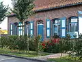 Mairie Hardifort
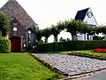 Kirche Saint-Martin mit separatem Glockenturm (Klockhuis / maison des cloches)
Siehe auch
Literatur
- Le Patrimoine des Communes du Nord. Flohic Editions, Band 1, Paris 2001, ISBN 2-84234-119-8, S. 466–467.
Weblinks
Commons: Hardifort – Sammlung von Bildern, Videos und Audiodateien
This article is issued from Wikipedia. The text is licensed under Creative Commons - Attribution - Sharealike. The authors of the article are listed here. Additional terms may apply for the media files, click on images to show image meta data.