La Chapelle-Saint-Aubert
La Chapelle-Saint-Aubert (bretonisch: Chapel-Sant-Alverzh; Gallo: La Chapèll-Saent-Aubèrt) ist eine französische Gemeinde mit 452 Einwohnern (Stand: 1. Januar 2019) im Département Ille-et-Vilaine in der Region Bretagne; sie gehört zum Arrondissement Fougères-Vitré und ist Teil des Kantons Fougères-1 (bis 2015: Kanton Fougères-Nord). Die Einwohner werden Chapelois genannt.
| La Chapelle-Saint-Aubert Chapel-Sant-Alverzh | ||
|---|---|---|
| ||
| Staat | Frankreich | |
| Region | Bretagne | |
| Département (Nr.) | Ille-et-Vilaine (35) | |
| Arrondissement | Fougères-Vitré | |
| Kanton | Fougères-1 | |
| Gemeindeverband | Fougères Agglomération | |
| Koordinaten | 48° 19′ N, 1° 18′ W | |
| Höhe | 51–128 m | |
| Fläche | 10,01 km² | |
| Einwohner | 452 (1. Januar 2019) | |
| Bevölkerungsdichte | 45 Einw./km² | |
| Postleitzahl | 35140 | |
| INSEE-Code | 35063 | |
_Mairie.jpg.webp) Rathaus von La Chapelle-Saint-Aubert | ||

Geographie
La Chapelle-Saint-Aubert liegt etwa neun Kilometer westsüdwestlich von Fougères. Der Couesnon begrenzt die Gemeinde im Süden. Umgeben wird La Chapelle-Saint-Aubert von den Nachbargemeinden Saint-Sauveur-des-Landes im Norden, Romagné im Osten und Nordosten, Billé im Südosten sowie Rives-du-Couesnon im Süden und Westen.
Bevölkerungsentwicklung
| Jahr | 1962 | 1968 | 1975 | 1982 | 1990 | 1999 | 2006 | 2013 |
| Einwohner | 379 | 399 | 352 | 377 | 387 | 359 | 399 | 426 |
Quellen: INSEE | ||||||||
Sehenswürdigkeiten
- Kirche Saint-Aubert
Literatur
- Le Patrimoine des Communes d’Ille-et-Vilaine. Flohic Editions, Band 2, Paris 2000, ISBN 2-84234-072-8, S. 1411–1413.
Weblinks
Commons: La Chapelle-Saint-Aubert – Sammlung von Bildern, Videos und Audiodateien
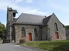
Kirche Saint-Aubert
This article is issued from Wikipedia. The text is licensed under Creative Commons - Attribution - Sharealike. The authors of the article are listed here. Additional terms may apply for the media files, click on images to show image meta data.