Villamée
| Villamée Gwilavez | ||
|---|---|---|

|
| |
| Staat | Frankreich | |
| Region | Bretagne | |
| Département (Nr.) | Ille-et-Vilaine (35) | |
| Arrondissement | Fougères-Vitré | |
| Kanton | Fougères-2 | |
| Gemeindeverband | Fougères Agglomération | |
| Koordinaten | 48° 28′ N, 1° 13′ W | |
| Höhe | 134–171 m | |
| Fläche | 10,92 km² | |
| Einwohner | 306 (1. Januar 2019) | |
| Bevölkerungsdichte | 28 Einw./km² | |
| Postleitzahl | 35420 | |
| INSEE-Code | 35357 | |
_Mairie.jpg.webp) Rathaus von Villamée | ||

Villamée (bretonisch: Gwilavez; Gallo: Vilaemaé) ist eine französische Gemeinde mit 306 Einwohnern (Stand: 1. Januar 2019) im Département Ille-et-Vilaine in der Region Bretagne; sie gehört zum Arrondissement Fougères-Vitré und ist Teil des Kantons Fougères-2 (bis 2015: Kanton Louvigné-du-Désert). Die Einwohner werden Villaméens genannt.
Geographie
Villamée liegt etwa zwölf Kilometer nördlich von Fougères. Umgeben wird Villamée von den Nachbargemeinden Saint-Georges-de-Reintembault im Norden, Mellé im Norden und Nordosten, Louvigné-du-Désert im Osten und Nordosten, Parigné im Süden und Südosten, Le Châtellier im Südwesten sowie Poilley im Westen und Nordwesten.
Bevölkerungsentwicklung
| Jahr | 1962 | 1968 | 1975 | 1982 | 1990 | 1999 | 2006 | 2013 |
| Einwohner | 490 | 470 | 417 | 377 | 334 | 314 | 317 | 323 |
Quelle: INSEE | ||||||||
Sehenswürdigkeiten
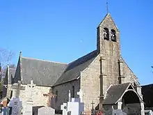
Kirche Saint-Martin
Siehe auch: Liste der Monuments historiques in Villamée
- Kirche Saint-Martin aus dem 11. Jahrhundert, Umbauten aus dem 15./16. Jahrhundert, seit 1926 Monument historique
- Herrenhaus Le Haut-Coudray aus dem 17. Jahrhundert
Weblinks
Commons: Villamée – Sammlung von Bildern, Videos und Audiodateien
Literatur
- Le Patrimoine des Communes d’Ille-et-Vilaine. Flohic Editions, Band 1, Paris 2000, ISBN 2-84234-072-8, S. 858–861.
This article is issued from Wikipedia. The text is licensed under Creative Commons - Attribution - Sharealike. The authors of the article are listed here. Additional terms may apply for the media files, click on images to show image meta data.