Monthault
Monthault (bretonisch: Brennaod; Gallo: Montaut) ist eine französische Gemeinde mit 250 Einwohnern (Stand: 1. Januar 2019) im Département Ille-et-Vilaine in der Region Bretagne; sie gehört zum Arrondissement Fougères-Vitré und ist Teil des Kantons Fougères-2 (bis 2015: Kanton Louvigné-du-Désert). Die Einwohner werden Monthaltais genannt.
| Monthault Brennaod | ||
|---|---|---|
| ||
| Staat | Frankreich | |
| Region | Bretagne | |
| Département (Nr.) | Ille-et-Vilaine (35) | |
| Arrondissement | Fougères-Vitré | |
| Kanton | Fougères-2 | |
| Gemeindeverband | Fougères Agglomération | |
| Koordinaten | 48° 31′ N, 1° 11′ W | |
| Höhe | 114–197 m | |
| Fläche | 8,32 km² | |
| Einwohner | 250 (1. Januar 2019) | |
| Bevölkerungsdichte | 30 Einw./km² | |
| Postleitzahl | 35420 | |
| INSEE-Code | 35190 | |
_Ancienne_mairie.jpg.webp) Rathaus von Monthault | ||

Geographie
Monthault liegt etwa 17 Kilometer nördlich von Fougères. Umgeben wird Monthault von den Nachbargemeinden Saint-Hilaire-du-Harcouët (Ortsteil: Saint-Martin-de-Landelles) im Norden, Saint-Brice-de-Landelles im Nordosten, Louvigné-du-Désert im Osten, Mellé im Süden sowie Saint-Georges-de-Reintembault im Westen.
Bevölkerungsentwicklung
| Jahr | 1962 | 1968 | 1975 | 1982 | 1990 | 1999 | 2006 | 2013 |
| Einwohner | 517 | 452 | 387 | 338 | 293 | 249 | 249 | 264 |
Quelle: INSEE | ||||||||
Sehenswürdigkeiten
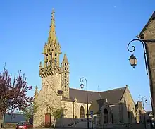
- Kirche Saint-Pierre aus der ersten Hälfte des 18. Jahrhunderts, teilweise bereits aus dem 17. Jahrhundert
- Herrenhaus La Chalopais aus dem 18. Jahrhundert
- Kapelle von Le Rocher aus dem Jahre 1877
Literatur
- Le Patrimoine des Communes d’Ille-et-Vilaine. Flohic Editions, Band 1, Paris 2000, ISBN 2-84234-072-8, S. 843–846.
This article is issued from Wikipedia. The text is licensed under Creative Commons - Attribution - Sharealike. The authors of the article are listed here. Additional terms may apply for the media files, click on images to show image meta data.