Montreuil-sous-Pérouse
Montreuil-sous-Pérouse ist eine Gemeinde im französischen Département Ille-et-Vilaine in der Bretagne. Sie gehört zum Kanton Vitré im Arrondissement Fougères-Vitré. Sie grenzt im Norden an Taillis, im Osten an Balazé, im Süden an Vitré, im Südwesten an Pocé-les-Bois und Champeaux und im Nordwesten an Landavran. Die Cantache, ein Nebenfluss der Vilaine, passiert Montreuil-sous-Pérouse und bildet an der westlichen Gemeindegrenze den See namens Étang de la Cantache. Dieser nimmt auch den Fluss Pérouse auf.
| Montreuil-sous-Pérouse | ||
|---|---|---|
| ||
| Staat | Frankreich | |
| Region | Bretagne | |
| Département (Nr.) | Ille-et-Vilaine (35) | |
| Arrondissement | Fougères-Vitré | |
| Kanton | Vitré | |
| Gemeindeverband | Vitré Communauté | |
| Koordinaten | 48° 9′ N, 1° 14′ W | |
| Höhe | 53–125 m | |
| Fläche | 16,15 km² | |
| Einwohner | 1.006 (1. Januar 2019) | |
| Bevölkerungsdichte | 62 Einw./km² | |
| Postleitzahl | 35500 | |
| INSEE-Code | 35194 | |

Bevölkerungsentwicklung
| Jahr | 1962 | 1968 | 1975 | 1982 | 1990 | 1999 | 2006 | 2013 |
|---|---|---|---|---|---|---|---|---|
| Einwohner | 505 | 509 | 559 | 798 | 889 | 928 | 1.027 | 1.029 |
Sehenswürdigkeiten
- Kirche Saint-Pierre et Saint-Paul
- Kapelle Pérouse
- Kriegerdenkmal
_%C3%89glise_01.jpg.webp) Kirche Saint-Pierre et Saint-Paul
Kirche Saint-Pierre et Saint-Paul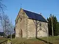 La Chapelle de Pérouse
_Mairie.jpg.webp) Mairie Montreuil-sous-Pérouse
Mairie Montreuil-sous-Pérouse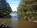 Der Fluss Pérouse
Literatur
- Le Patrimoine des Communes d’Ille-et-Vilaine. Flohic Editions, Band 2, Paris 2000, ISBN 2-84234-072-8, S. 1706–1710.
This article is issued from Wikipedia. The text is licensed under Creative Commons - Attribution - Sharealike. The authors of the article are listed here. Additional terms may apply for the media files, click on images to show image meta data.