Combourtillé
Combourtillé (bretonisch: Komorzhel; Gallo: Conbórtilhaè) ist eine französische Gemeinde mit 611 Einwohnern (Stand: 1. Januar 2019) im Département Ille-et-Vilaine in der Region Bretagne. Combourtillé gehört zum Arrondissement Fougères-Vitré und zum Kanton Fougères-1 (bis 2015: Kanton Fougères-Sud). Die Einwohner werden Combourtilléens genannt.
| Combourtillé Komorzhel | ||
|---|---|---|
| ||
| Staat | Frankreich | |
| Region | Bretagne | |
| Département (Nr.) | Ille-et-Vilaine (35) | |
| Arrondissement | Fougères-Vitré | |
| Kanton | Fougères-1 | |
| Gemeindeverband | Fougères Agglomération | |
| Koordinaten | 48° 16′ N, 1° 15′ W | |
| Höhe | 72–130 m | |
| Fläche | 9,21 km² | |
| Einwohner | 611 (1. Januar 2019) | |
| Bevölkerungsdichte | 66 Einw./km² | |
| Postleitzahl | 35210 | |
| INSEE-Code | 35086 | |
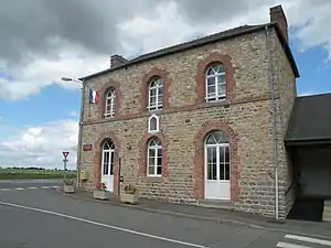 Rathaus von Combourtillé | ||

Geografie
Combourtillé liegt im Osten der Bretagne. Umgeben wird Combourtillé von den Nachbargemeinden Billé im Norden, Montreuil-des-Landes im Osten und Südosten, Mecé im Süden und Südwesten sowie Rives-du-Couesnon mit Saint-Georges-de-Chesné im Westen. An der nördlichen Gemeindegrenze verläuft das Flüsschen Général, das hier noch Rivière de Billé genannt wird.
Bevölkerungsentwicklung
| 1962 | 1968 | 1975 | 1982 | 1990 | 1999 | 2006 | 2017 |
|---|---|---|---|---|---|---|---|
| 425 | 416 | 370 | 340 | 363 | 401 | 515 | 611 |
| Quellen: Cassini und INSEE | |||||||
Sehenswürdigkeiten
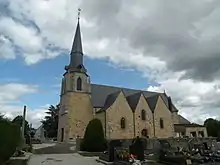
Kirche Notre-Dame
- Kirche Notre-Dame aus dem 16. Jahrhundert
Literatur
- Le Patrimoine des Communes d’Ille-et-Vilaine. Flohic Editions, Band 1, Paris 2000, ISBN 2-84234-072-8, S. 572–573.
This article is issued from Wikipedia. The text is licensed under Creative Commons - Attribution - Sharealike. The authors of the article are listed here. Additional terms may apply for the media files, click on images to show image meta data.