Champmotteux
Champmotteux ist eine französische Gemeinde mit 370 Einwohnern (Stand: 1. Januar 2019) im Département Essonne in der Region Île-de-France; sie gehört zum Arrondissement Étampes und ist Teil des Kantons Étampes (bis 2015: Kanton Méréville). Die Einwohner werden Champmottois genannt.
| Champmotteux | ||
|---|---|---|
| ||
| Staat | Frankreich | |
| Region | Île-de-France | |
| Département (Nr.) | Essonne (91) | |
| Arrondissement | Étampes | |
| Kanton | Étampes | |
| Gemeindeverband | Étampois Sud Essonne | |
| Koordinaten | 48° 21′ N, 2° 19′ O | |
| Höhe | 102–147 m | |
| Fläche | 7,55 km² | |
| Einwohner | 370 (1. Januar 2019) | |
| Bevölkerungsdichte | 49 Einw./km² | |
| Postleitzahl | 91150 | |
| INSEE-Code | 91137 | |

Geographie
Champmotteux liegt etwa 57 Kilometer südlich von Paris. Die Gemeinde liegt im Regionalen Naturpark Gâtinais français. Umgeben wird Champmotteux von den Nachbargemeinden Mespuits im Norden und Nordwesten, Gironville-sur-Essonne im Norden und Nordosten, Prunay-sur-Essonne im Osten und Nordosten, Boigneville im Osten, Le Malesherbois mit Nangeville im Süden sowie Brouy im Westen und Südwesten.
Bevölkerungsentwicklung
| Jahr | 1962 | 1968 | 1975 | 1982 | 1990 | 1999 | 2006 | 2013 |
| Einwohner | 165 | 139 | 136 | 198 | 220 | 241 | 308 | 385 |
| Quelle: Cassini und INSEE | ||||||||
Sehenswürdigkeiten
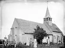
Kirche Sainte-Madeleine
- Kirche Sainte-Madeleine
Literatur
- Le Patrimoine des Communes de l’Essonne. Flohic Éditions, Paris 2001, Band 2, ISBN 2-84234-126-0, S. 646–649.
Weblinks
Commons: Champmotteux – Sammlung von Bildern, Videos und Audiodateien
This article is issued from Wikipedia. The text is licensed under Creative Commons - Attribution - Sharealike. The authors of the article are listed here. Additional terms may apply for the media files, click on images to show image meta data.