Prunay-sur-Essonne
Prunay-sur-Essonne ist eine französische Gemeinde mit 289 Einwohnern (Stand: 1. Januar 2019) im Département Essonne in der Region Île-de-France. Sie gehört zum Arrondissement Évry und zum Kanton Mennecy. Die Einwohner werden Prunaysiens genannt.
| Prunay-sur-Essonne | ||
|---|---|---|
| ||
| Staat | Frankreich | |
| Region | Île-de-France | |
| Département (Nr.) | Essonne (91) | |
| Arrondissement | Évry | |
| Kanton | Mennecy | |
| Gemeindeverband | Deux Vallées | |
| Koordinaten | 48° 21′ N, 2° 23′ O | |
| Höhe | 65–146 m | |
| Fläche | 5,08 km² | |
| Einwohner | 289 (1. Januar 2019) | |
| Bevölkerungsdichte | 57 Einw./km² | |
| Postleitzahl | 91720 | |
| INSEE-Code | 91507 | |
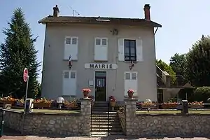 Rathaus (Mairie) von Prunay-sur-Essonne | ||

Geographie
Prunay-sur-Essonne liegt etwa 55 Kilometer südlich von Paris am Fluss Essonne, der die östliche Gemeindegrenze bildet. Die Gemeinde liegt im Regionalen Naturpark Gâtinais français. Umgeben wird Prunay-sur-Essonne von den Nachbargemeinden Gironville-sur-Essonne im Norden, Buno-Bonnevaux im Osten, Boigneville im Süden sowie Champmotteux im Westen und Südwesten.
Bevölkerungsentwicklung
| 1962 | 1968 | 1975 | 1982 | 1990 | 1999 | 2006 | 2019 |
|---|---|---|---|---|---|---|---|
| 123 | 132 | 198 | 240 | 279 | 286 | 305 | 289 |
| Quellen: Cassini und INSEE | |||||||
Sehenswürdigkeiten
- Menhir La Pierre Droite
- Kirche Saint-Martin
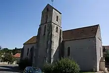
Kirche Saint-Martin
Literatur
- Le Patrimoine des Communes de l’Essonne. Flohic Éditions, Band 2, Paris 2001, ISBN 2-84234-126-0, S. 756–758.
Weblinks
Commons: Prunay-sur-Essonne – Sammlung von Bildern, Videos und Audiodateien
This article is issued from Wikipedia. The text is licensed under Creative Commons - Attribution - Sharealike. The authors of the article are listed here. Additional terms may apply for the media files, click on images to show image meta data.