La Forêt-le-Roi
| La Forêt-le-Roi | ||
|---|---|---|
.svg.png.webp)
|
| |
| Staat | Frankreich | |
| Region | Île-de-France | |
| Département (Nr.) | Essonne (91) | |
| Arrondissement | Étampes | |
| Kanton | Dourdan | |
| Gemeindeverband | Dourdannais en Hurepoix | |
| Koordinaten | 48° 29′ N, 2° 3′ O | |
| Höhe | 108–156 m | |
| Fläche | 7,96 km² | |
| Einwohner | 519 (1. Januar 2019) | |
| Bevölkerungsdichte | 65 Einw./km² | |
| Postleitzahl | 91410 | |
| INSEE-Code | 91247 | |
| Website | http://laforetleroi.free.fr/ | |
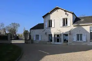 Rathaus (Mairie) von La Forêt-le-Roi | ||

La Forêt-le-Roi ist eine französische Gemeinde mit 519 Einwohnern (Stand: 1. Januar 2019) im Département Essonne in der Region Île-de-France; sie gehört zum Arrondissement Étampes und zum Kanton Dourdan. Die Einwohner heißen Forestains.
Geographie
La Forêt-le-Roi liegt etwa 47 Kilometer südsüdwestlich von Paris. Umgeben wird La Forêt-le-Roi von den Nachbargemeinden Roinville im Norden, Boissy-le-Sec im Osten, Boutervilliers im Süden, Richarville im Westen sowie Les Granges-le-Roi im Nordwesten.
Bevölkerungsentwicklung
| Jahr | 1962 | 1968 | 1975 | 1982 | 1990 | 1999 | 2006 | 2012 |
| Einwohner | 230 | 218 | 264 | 330 | 338 | 357 | 444 | 499 |
| Quelle: Cassini und INSEE | ||||||||
Sehenswürdigkeiten
- Kirche Saint-Nicolas und Saint-Blaise
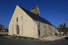
Kirche Saint-Nicolas und Saint-Blaise
Literatur
- Le Patrimoine des Communes de l’Essonne. Flohic Éditions, Band 1, Paris 2001, ISBN 2-84234-126-0, S. 227–228.
Weblinks
Commons: La Forêt-le-Roi – Sammlung von Bildern, Videos und Audiodateien
This article is issued from Wikipedia. The text is licensed under Creative Commons - Attribution - Sharealike. The authors of the article are listed here. Additional terms may apply for the media files, click on images to show image meta data.