Kanton Étampes
Der Kanton Étampes ist ein französischer Wahlkreis im Arrondissement Étampes, im Département Essonne und in der Region Île-de-France; sein Hauptort ist Étampes, Vertreter im Generalrat des Départements ist seit 2008 Jean Perthuis (zunächst UMP, dann Parti radical valoisien).
| Kanton Étampes | |
|---|---|
| Region | Île-de-France |
| Département | Essonne |
| Arrondissement | Étampes |
| Hauptort | Étampes |
| Einwohner | 63.850 (1. Jan. 2019) |
| Bevölkerungsdichte | 115 Einw./km² |
| Fläche | 554,14 km² |
| Gemeinden | 44 |
| INSEE-Code | 9108 |
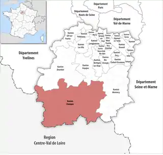 Lage des Kantons Étampes im Département Essonne | |
Gemeinden
Der Kanton besteht aus 44 Gemeinden mit insgesamt 82.420 Einwohnern (Stand: 1. Januar 2019) auf einer Gesamtfläche von 19,14 km²:
| Gemeinde | Einwohner 1. Januar 2019 |
Fläche km² |
Dichte Einw./km² |
Code INSEE |
Postleitzahl |
|---|---|---|---|---|---|
| Abbéville-la-Rivière | 324 | 15,00 | 22 | 91001 | 91150 |
| Angerville | 4.353 | 25,80 | 169 | 91016 | 91670 |
| Arrancourt | 135 | 7,57 | 18 | 91022 | 91690 |
| Authon-la-Plaine | 374 | 10,48 | 36 | 91035 | 91410 |
| Auvers-Saint-Georges | 1.273 | 12,75 | 100 | 91038 | 91580 |
| Blandy | 117 | 7,91 | 15 | 91067 | 91150 |
| Bois-Herpin | 80 | 3,97 | 20 | 91075 | 91150 |
| Boissy-la-Rivière | 510 | 12,50 | 41 | 91079 | 91690 |
| Boissy-le-Cutté | 1.341 | 4,60 | 292 | 91080 | 91590 |
| Boissy-le-Sec | 689 | 19,35 | 36 | 91081 | 91870 |
| Boutervilliers | 426 | 7,11 | 60 | 91098 | 91150 |
| Bouville | 646 | 20,93 | 31 | 91100 | 91880 |
| Brières-les-Scellés | 1.260 | 8,59 | 147 | 91109 | 91150 |
| Brouy | 128 | 8,48 | 15 | 91112 | 91150 |
| Cerny | 3.337 | 17,25 | 193 | 91129 | 91590 |
| Chalo-Saint-Mars | 1.026 | 29,00 | 35 | 91130 | 91780 |
| Chalou-Moulineux | 404 | 10,75 | 38 | 91131 | 91740 |
| Champmotteux | 370 | 7,55 | 49 | 91137 | 91150 |
| Chatignonville | 69 | 5,20 | 13 | 91145 | 91410 |
| Congerville-Thionville | 216 | 8,38 | 26 | 91613 | 91740 |
| D’Huison-Longueville | 1.495 | 9,98 | 150 | 91198 | 91590 |
| Étampes | 25.629 | 46,01 | 557 | 91223 | 91150 |
| Fontaine-la-Rivière | 182 | 3,73 | 49 | 91240 | 91690 |
| Guillerval | 814 | 17,34 | 47 | 91294 | 91690 |
| La Forêt-Sainte-Croix | 161 | 5,28 | 30 | 91248 | 91150 |
| Le Mérévillois | 3.305 | 33,27 | 99 | 91390 | 91660 |
| Marolles-en-Beauce | 237 | 6,00 | 40 | 91374 | 91150 |
| Mérobert | 625 | 10,66 | 59 | 91393 | 91780 |
| Mespuits | 227 | 9,98 | 23 | 91399 | 91150 |
| Monnerville | 382 | 8,28 | 46 | 91414 | 91930 |
| Morigny-Champigny | 4.346 | 30,94 | 140 | 91433 | 91150 |
| Ormoy-la-Rivière | 911 | 10,42 | 87 | 91469 | 91150 |
| Orveau | 168 | 4,27 | 39 | 91473 | 91590 |
| Plessis-Saint-Benoist | 337 | 9,21 | 37 | 91495 | 91410 |
| Puiselet-le-Marais | 258 | 11,33 | 23 | 91508 | 91150 |
| Pussay | 2.106 | 11,59 | 182 | 91511 | 91740 |
| Roinvilliers | 107 | 7,15 | 15 | 91526 | 91150 |
| Saclas | 1.859 | 13,69 | 136 | 91533 | 91690 |
| Saint-Cyr-la-Rivière | 524 | 8,75 | 60 | 91544 | 91690 |
| Saint-Escobille | 506 | 11,99 | 42 | 91547 | 91410 |
| Saint-Hilaire | 410 | 6,83 | 60 | 91556 | 91780 |
| Valpuiseaux | 620 | 18,71 | 33 | 91629 | 91720 |
| Vayres-sur-Essonne | 959 | 8,46 | 113 | 91639 | 91820 |
| Villeneuve-sur-Auvers | 604 | 7,10 | 85 | 91671 | 91580 |
| Kanton Étampes | 63.850 | 554,14 | 115 | 9108 | – |
Bis zur Neuordnung bestand der Kanton Étampes aus den elf Gemeinden Boissy-le-Sec, Boutervilliers, Bouville, Brières-les-Scellés, Chalo-Saint-Mars, Étampes, Morigny-Champigny, Ormoy-la-Rivière, Puiselet-le-Marais, Saint-Hilaire und Valpuiseaux. Sein Zuschnitt entsprach einer Fläche von 202,74 km2.
Bevölkerungsentwicklung
| 1968 | 1975 | 1982 | 1990 | 1999 | 2006 | 2011 |
|---|---|---|---|---|---|---|
| 21.428 | 25.582 | 27.065 | 30.333 | 31.313 | 32.589 | 34.453 |
Veränderungen im Gemeindebestand seit 2016
- 2019: Fusion Estouches und Méréville → Le Mérévillois
This article is issued from Wikipedia. The text is licensed under Creative Commons - Attribution - Sharealike. The authors of the article are listed here. Additional terms may apply for the media files, click on images to show image meta data.