Vouthon-Haut
| Vouthon-Haut | ||
|---|---|---|
|
| |
| Staat | Frankreich | |
| Region | Grand Est | |
| Département (Nr.) | Meuse (55) | |
| Arrondissement | Commercy | |
| Kanton | Ligny-en-Barrois | |
| Gemeindeverband | Haute Saulx et Perthois-Val d’Ornois | |
| Koordinaten | 48° 29′ N, 5° 37′ O | |
| Höhe | 308–441 m | |
| Fläche | 13,39 km² | |
| Einwohner | 86 (1. Januar 2019) | |
| Bevölkerungsdichte | 6 Einw./km² | |
| Postleitzahl | 55130 | |
| INSEE-Code | 55575 | |
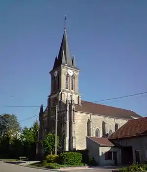 Kirche Saint-Sigismond | ||

Vouthon-Haut ist eine französische Gemeinde mit 86 Einwohnern (Stand 1. Januar 2019) im Département Meuse in der Region Grand Est (bis 2015 Lothringen).
Geografie
Die Gemeinde liegt rund 30 Kilometer südwestlich von Toul. Nachbargemeinden von Vouthon-Haut sind Vouthon-Bas im Norden, Goussaincourt im Osten, Les Roises im Südosten, Vaudeville-le-Haut im Süden und Gondrecourt-le-Château im Westen.
Bevölkerungsentwicklung
| Jahr | 1793 | 1856 | 1901 | 1946 | 1962 | 1968 | 1975 | 1982 | 1990 | 1999 | 2007 | 2014 |
| Einwohner | 342 | 310 | 232 | 111 | 86 | 70 | 77 | 90 | 95 | 79 | 73 | 75 |
Sehenswürdigkeiten
- Kirche Saint-Sigismond
Literatur
- Le Patrimoine des Communes de la Meuse. Flohic Editions, Band 1, Paris 1999, ISBN 2-84234-074-4, S. 505.
This article is issued from Wikipedia. The text is licensed under Creative Commons - Attribution - Sharealike. The authors of the article are listed here. Additional terms may apply for the media files, click on images to show image meta data.