Ranzières
| Ranzières | ||
|---|---|---|

|
| |
| Staat | Frankreich | |
| Region | Grand Est | |
| Département (Nr.) | Meuse (55) | |
| Arrondissement | Commercy | |
| Kanton | Saint-Mihiel | |
| Gemeindeverband | Sammiellois | |
| Koordinaten | 49° 1′ N, 5° 30′ O | |
| Höhe | 215–360 m | |
| Fläche | 13,94 km² | |
| Einwohner | 86 (1. Januar 2019) | |
| Bevölkerungsdichte | 6 Einw./km² | |
| Postleitzahl | 55300 | |
| INSEE-Code | 55415 | |

Ranzières ist eine französische Gemeinde mit 86 Einwohnern (Stand: 1. Januar 2019) im Département Meuse in der Region Grand Est (bis 2015 Lothringen). Die Gemeinde gehört zum Arrondissement Commercy und zum Kanton Saint-Mihiel. Die Einwohner werden Ranzièrois genannt.
Geografie
Ranzières liegt etwa 17 Kilometer südsüdöstlich von Verdun. Das Gemeindegebiet ist Teil des Regionalen Naturparks Lothringen. Umgeben wird Ranzières von den Nachbargemeinden Rupt-en-Woëvre im Norden, Mouilly im Norden und Nordosten, Vaux-lès-Palameix im Osten, Troyon im Süden und Südwesten sowie Ambly-sur-Meuse im Westen.
Bevölkerungsentwicklung
| Jahr | 1962 | 1968 | 1975 | 1982 | 1990 | 1999 | 2006 | 2011 | 2016 |
| Einwohner | 112 | 92 | 78 | 70 | 56 | 70 | 66 | 71 | 80 |
| Quelle: Cassini und INSEE | |||||||||
Sehenswürdigkeiten
- Kirche Saint-Étienne, 1837 erbaut
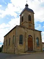
Kirche Saint-Étienne
Literatur
- Le Patrimoine des Communes de la Meuse. Flohic Editions, Band 2, Paris 1999, ISBN 2-84234-074-4, S. 824–826.
This article is issued from Wikipedia. The text is licensed under Creative Commons - Attribution - Sharealike. The authors of the article are listed here. Additional terms may apply for the media files, click on images to show image meta data.