Santilly (Saône-et-Loire)
Santilly ist eine französische Gemeinde mit 132 Einwohnern (Stand: 1. Januar 2019) im Département Saône-et-Loire in der Region Bourgogne-Franche-Comté (vor 2016 Bourgogne). Die Gemeinde gehört zum Arrondissement Chalon-sur-Saône und zum Kanton Givry (bis 2015: Buxy).
| Santilly | ||
|---|---|---|
| ||
| Staat | Frankreich | |
| Region | Bourgogne-Franche-Comté | |
| Département (Nr.) | Saône-et-Loire (71) | |
| Arrondissement | Chalon-sur-Saône | |
| Kanton | Givry | |
| Gemeindeverband | Sud Côte Chalonnaise | |
| Koordinaten | 46° 37′ N, 4° 42′ O | |
| Höhe | 187–305 m | |
| Fläche | 7,23 km² | |
| Einwohner | 132 (1. Januar 2019) | |
| Bevölkerungsdichte | 18 Einw./km² | |
| Postleitzahl | 71460 | |
| INSEE-Code | 71498 | |

Lage
Santilly liegt etwa 20 Kilometer südwestlich von Chalon-sur-Saône. Umgeben wird Santilly von den Nachbargemeinden Saint-Boil im Norden, Messey-sur-Grosne im Nordosten, La Chapelle-de-Bragny im Osten und Südosten, Sercy im Süden sowie Saint-Gengoux-le-National im Westen.
Bevölkerung
| Jahr | 1962 | 1968 | 1975 | 1982 | 1990 | 1999 | 2006 | 2011 | 2016 |
|---|---|---|---|---|---|---|---|---|---|
| Einwohnerzahl | 148 | 120 | 111 | 130 | 109 | 107 | 134 | 143 | 136 |
| Quelle: Cassini und INSEE | |||||||||
Sehenswürdigkeiten
- Kirche Saint-Victor aus dem 12. Jahrhundert
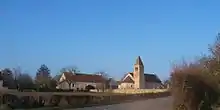
Kirche Saint-Victor
Weblinks
Commons: Santilly – Sammlung von Bildern, Videos und Audiodateien
This article is issued from Wikipedia. The text is licensed under Creative Commons - Attribution - Sharealike. The authors of the article are listed here. Additional terms may apply for the media files, click on images to show image meta data.