Charnay-lès-Chalon
Charnay-lès-Chalon ist eine französische Gemeinde mit 190 Einwohnern (Stand: 1. Januar 2019) im Département Saône-et-Loire in der Region Bourgogne-Franche-Comté (vor 2016 Bourgogne). Sie gehört zum Arrondissement Chalon-sur-Saône und ist Teil des Kantons Gergy (bis 2015 Verdun-sur-le-Doubs).
| Charnay-lès-Chalon | ||
|---|---|---|
| ||
| Staat | Frankreich | |
| Region | Bourgogne-Franche-Comté | |
| Département (Nr.) | Saône-et-Loire (71) | |
| Arrondissement | Chalon-sur-Saône | |
| Kanton | Gergy | |
| Gemeindeverband | Saône Doubs Bresse | |
| Koordinaten | 46° 56′ N, 5° 6′ O | |
| Höhe | 172–188 m | |
| Fläche | 9,20 km² | |
| Einwohner | 190 (1. Januar 2019) | |
| Bevölkerungsdichte | 21 Einw./km² | |
| Postleitzahl | 71350 | |
| INSEE-Code | 71104 | |
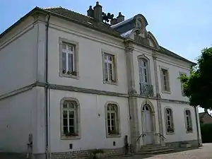 Rathaus (Mairie) von Charnay-lès-Chalon | ||

Geografie
Charnay-lès-Chalon liegt etwa 29 Kilometer nordöstlich von Chalon-sur-Saône zwischen Saône und Doubs. Umgeben wird Charnay-lès-Chalon von den Nachbargemeinden Écuelles im Norden, Chivres im Norden und Nordosten, Mont-lès-Seurre im Nordosten, Pontoux im Osten und Südosten, Saunières im Süden sowie Bragny-sur-Saône im Westen und Südwesten.
Bevölkerungsentwicklung
| Jahr | 1962 | 1968 | 1975 | 1982 | 1990 | 1999 | 2006 | 2011 | 2016 |
|---|---|---|---|---|---|---|---|---|---|
| Einwohner | 249 | 231 | 211 | 181 | 173 | 178 | 178 | 180 | 184 |
| Quellen: Cassini und INSEE | |||||||||
Sehenswürdigkeiten
- Kirche Saint-Grégoire-le-Grand
- Friedhofskreuz, Monument historique seit 1930
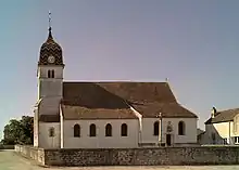
Kirche Saint-Grégoire-le-Grand
Weblinks
Commons: Charnay-lès-Chalon – Sammlung von Bildern, Videos und Audiodateien
This article is issued from Wikipedia. The text is licensed under Creative Commons - Attribution - Sharealike. The authors of the article are listed here. Additional terms may apply for the media files, click on images to show image meta data.