Saint-Gervais-en-Vallière
Saint-Gervais-en-Vallière ist eine französische Gemeinde mit 433 Einwohnern (Stand 1. Januar 2019) im Département Saône-et-Loire in der Region Bourgogne-Franche-Comté (vor 2016 Bourgogne). Sie gehört zum Arrondissement Chalon-sur-Saône und zum Kanton Gergy (bis 2015 Verdun-sur-le-Doubs).
| Saint-Gervais-en-Vallière | ||
|---|---|---|
| ||
| Staat | Frankreich | |
| Region | Bourgogne-Franche-Comté | |
| Département (Nr.) | Saône-et-Loire (71) | |
| Arrondissement | Chalon-sur-Saône | |
| Kanton | Gergy | |
| Gemeindeverband | Saône Doubs Bresse | |
| Koordinaten | 46° 56′ N, 4° 57′ O | |
| Höhe | 178–206 m | |
| Fläche | 16,43 km² | |
| Einwohner | 433 (1. Januar 2019) | |
| Bevölkerungsdichte | 26 Einw./km² | |
| Postleitzahl | 71350 | |
| INSEE-Code | 71423 | |

Geographie
Saint-Gervais-en-Vallière liegt etwa fünfzig Kilometer südsüdwestlich von Dijon in der Naturlandschaft Bresse. Umgeben wird Saint-Maurice-en-Rivière von den Nachbargemeinden Saint-Loup-Géanges im Norden und Westen, Chevigny-en-Vallière im Norden, Saint-Martin-en-Gâtinois im Osten sowie Allerey-sur-Saône im Süden.
Bevölkerungsentwicklung
| Jahr | 1962 | 1968 | 1975 | 1982 | 1990 | 1999 | 2006 | 2013 |
| Einwohner | 307 | 292 | 242 | 258 | 269 | 305 | 356 | 441 |
| Quelle: Cassini und INSEE | ||||||||
Sehenswürdigkeiten
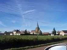
Kirche Saint-Gervais
- Kirche Saint-Gervais aus dem 14. Jahrhundert
Weblinks
Commons: Saint-Gervais-en-Vallière – Sammlung von Bildern, Videos und Audiodateien
This article is issued from Wikipedia. The text is licensed under Creative Commons - Attribution - Sharealike. The authors of the article are listed here. Additional terms may apply for the media files, click on images to show image meta data.