Saint-Molf
Saint-Molf (bretonisch Sant-Molf) ist eine französische Gemeinde mit 2.716 Einwohnern (Stand: 1. Januar 2019) im Département Loire-Atlantique in der Region Pays de la Loire. Saint-Molf gehört zum Arrondissement Saint-Nazaire und zum Kanton Guérande. Die Einwohner werden Mendulphins genannt.
| Saint-Molf Sant-Molf | ||
|---|---|---|
.svg.png.webp)
|
| |
| Staat | Frankreich | |
| Region | Pays de la Loire | |
| Département (Nr.) | Loire-Atlantique (44) | |
| Arrondissement | Saint-Nazaire | |
| Kanton | Guérande | |
| Gemeindeverband | Presqu’île de Guérande Atlantique | |
| Koordinaten | 47° 24′ N, 2° 25′ W | |
| Höhe | 0–30 m | |
| Fläche | 23,24 km² | |
| Einwohner | 2.716 (1. Januar 2019) | |
| Bevölkerungsdichte | 117 Einw./km² | |
| Postleitzahl | 44350 | |
| INSEE-Code | 44183 | |
| Website | https://www.mairie-saint-molf.fr/ | |

Geographie
Saint-Molf liegt nahe der Atlantikküste (Golf von Biskaya) auf der Halbinsel von Guérande im Regionalen Naturpark Brière (französisch: Parc naturel régional de Brière) mit zahlreichen Salzwiesen (Marais). Umgeben wird Saint-Molf von den Nachbargemeinden Assérac im Norden, Herbignac im Osten und Nordosten, Guérande im Süden, La Turballe im Südwesten sowie Mesquer im Westen.
Bevölkerungsentwicklung
| Jahr | 1962 | 1968 | 1975 | 1982 | 1990 | 1999 | 2006 | 2017 |
| Einwohner | 753 | 690 | 706 | 852 | 1154 | 1500 | 2030 | 2622 |
| Quellen: Cassini und INSEE | ||||||||
Sehenswürdigkeiten
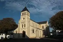
Kirche Saint-Molf
- Kirche Saint-Molf, 1851 erbaut
- Wegekreuz und Kapelle
- Windmühlen
Literatur
- Le Patrimoine des Communes de la Loire-Atlantique. Flohic Editions, Band 1, Charenton-le-Pont 1999, ISBN 2-84234-040-X, S. 446–449.
This article is issued from Wikipedia. The text is licensed under Creative Commons - Attribution - Sharealike. The authors of the article are listed here. Additional terms may apply for the media files, click on images to show image meta data.