Le Pouliguen
Le Pouliguen (bretonisch: Ar Poulgwenn) ist eine französische Gemeinde mit 4015 Einwohnern (Stand: 1. Januar 2019) im Département Loire-Atlantique in der Region Pays de la Loire. Sie ist Teil des Arrondissements Nantes und des Kantons La Baule-Escoublac (bis 2015: Kanton Le Croisic) und gehört zum Gemeindeverband Presqu’île de Guérande Atlantique.
| Le Pouliguen Ar Poulgwenn | ||
|---|---|---|
.svg.png.webp)
|
| |
| Staat | Frankreich | |
| Region | Pays de la Loire | |
| Département (Nr.) | Loire-Atlantique (44) | |
| Arrondissement | Nantes | |
| Kanton | La Baule-Escoublac | |
| Gemeindeverband | Presqu’île de Guérande Atlantique | |
| Koordinaten | 47° 17′ N, 2° 26′ W | |
| Höhe | 0–23 m | |
| Fläche | 4,46 km² | |
| Einwohner | 4.015 (1. Januar 2019) | |
| Bevölkerungsdichte | 900 Einw./km² | |
| Postleitzahl | 44510 | |
| INSEE-Code | 44135 | |
| Website | www.lepouliguen.fr/ | |
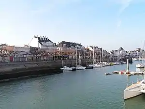 Hafenpromenade von Le Pouliguen | ||

Geografie
Le Pouliguen liegt am Atlantik, an der Côte d’Amour ("Liebesküste"). Nachbargemeinden sind: Guérande im Norden, La Baule-Escoublac im Nordosten sowie Batz-sur-Mer im Westen. Der Ort hat einen Bahnhof an der Bahnstrecke Saint-Nazaire–Le Croisic.
Bevölkerungsentwicklung
| Jahr | 1962 | 1968 | 1975 | 1982 | 1990 | 1999 | 2006 | 2017 |
|---|---|---|---|---|---|---|---|---|
| Einwohner | 3658 | 3788 | 4276 | 4383 | 4912 | 5265 | 5308 | 4275 |
Gemeindepartnerschaften
Mit der britischen Gemeinde Llantwit Major im County South Glamorgan (Wales) und mit der deutschen Gemeinde Kißlegg bestehen Partnerschaften.
Sehenswürdigkeiten
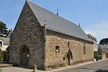
Kapelle von Penchâteau
- Höhle der Korrigans (französisch Grotte des Korrigans)
- Abschnittsbefestigung von Penchâteau, Gallier- und Keltenlager von Penchâteau, Gallierlager seit 1996 Monument historique, Keltenlager seit 1979 Monument historique
- Kapelle Saint-Julien-Sainte-Anne von Penchâteau aus dem 15. Jahrhundert, seit 1925 Monument historique
- Rathaus

Rathaus
Literatur
- Le Patrimoine des Communes de la Loire-Atlantique. Flohic Editions, Band 1, Charenton-le-Pont 1999, ISBN 2-84234-040-X, S. 352–357.
This article is issued from Wikipedia. The text is licensed under Creative Commons - Attribution - Sharealike. The authors of the article are listed here. Additional terms may apply for the media files, click on images to show image meta data.