Saint-Mard (Charente-Maritime)
Saint-Mard ist eine französische Gemeinde mit 1.206 Einwohnern (Stand: 1. Januar 2019) im Département Charente-Maritime in der Region Nouvelle-Aquitaine (vor 2016: Poitou-Charentes); sie gehört zum Arrondissement Rochefort und ist Teil des Kantons Surgères. Die Einwohner werden Saint-Mardois genannt.
| Saint-Mard | ||
|---|---|---|
| ||
| Staat | Frankreich | |
| Region | Nouvelle-Aquitaine | |
| Département (Nr.) | Charente-Maritime (17) | |
| Arrondissement | Rochefort | |
| Kanton | Surgères | |
| Gemeindeverband | Aunis Sud | |
| Koordinaten | 46° 5′ N, 0° 43′ W | |
| Höhe | 24–75 m | |
| Fläche | 20,94 km² | |
| Einwohner | 1.206 (1. Januar 2019) | |
| Bevölkerungsdichte | 58 Einw./km² | |
| Postleitzahl | 17700 | |
| INSEE-Code | 17359 | |

Geographie
Saint-Mard liegt etwa 34 Kilometer ostsüdöstlich von La Rochelle in der historischen Region Aunis. Umgeben wird Saint-Mard von den Nachbargemeinden Surgères im Norden und Westen, Saint-Saturnin-du-Bois im Norden, Marsais im Nordosten, Bernay-Saint-Martin im Osten und Südosten, Breuil-la-Réorte im Süden sowie La Devise im Südwesten.
Bevölkerungsentwicklung
| Jahr | 1962 | 1968 | 1975 | 1982 | 1990 | 1999 | 2008 | 2013 |
| Einwohner | 948 | 948 | 914 | 935 | 865 | 868 | 1.001 | 1.173 |
| Quelle: Cassini und INSEE | ||||||||
Sehenswürdigkeiten
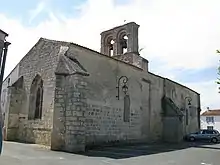
Kirche Saint-Mard
Siehe auch: Liste der Monuments historiques in Saint-Mard (Charente-Maritime)
- Kirche Saint-Médard
Literatur
- Le Patrimoine des Communes de la Charente-Maritime. Flohic Editions, Band 2, Paris 2002, ISBN 2-84234-129-5, S. 1082–1083.
Weblinks
Commons: Saint-Mard – Sammlung von Bildern, Videos und Audiodateien
This article is issued from Wikipedia. The text is licensed under Creative Commons - Attribution - Sharealike. The authors of the article are listed here. Additional terms may apply for the media files, click on images to show image meta data.