Lussant
Lussant ist eine französische Gemeinde mit 1.012 Einwohnern (Stand: 1. Januar 2019) im Département Charente-Maritime in der Region Nouvelle-Aquitaine. Lussant gehört zum Arrondissement Rochefort und zum Kanton Tonnay-Charente. Die Einwohner werden Lussantais genannt.
| Lussant | ||
|---|---|---|
| ||
| Staat | Frankreich | |
| Region | Nouvelle-Aquitaine | |
| Département (Nr.) | Charente-Maritime (17) | |
| Arrondissement | Rochefort | |
| Kanton | Tonnay-Charente | |
| Gemeindeverband | Rochefort Océan | |
| Koordinaten | 45° 58′ N, 0° 49′ W | |
| Höhe | 1–28 m | |
| Fläche | 8,98 km² | |
| Einwohner | 1.012 (1. Januar 2019) | |
| Bevölkerungsdichte | 113 Einw./km² | |
| Postleitzahl | 17430 | |
| INSEE-Code | 17216 | |
| Website | http://mairie-lussant.fr/ | |
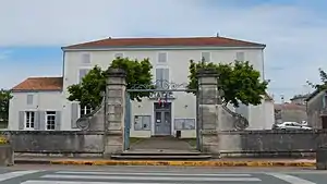 Rathaus (Mairie) von Lussant | ||

Geographie
Lussant liegt etwa elf Kilometer ostnordöstlich vom Stadtzentrum von Rochefort am Boutonne, die die Gemeinde im Süden begrenzt. Umgeben wird Lussant von den Nachbargemeinden Tonnay-Charente im Norden und Nordwesten, Moragne im Nordosten, Saint-Coutant-le-Grand im Osten, Champdolent im Süden und Südosten sowie Cabariot im Westen.
Bevölkerungsentwicklung
| Jahr | 1962 | 1968 | 1975 | 1982 | 1990 | 1999 | 2008 | 2013 |
|---|---|---|---|---|---|---|---|---|
| Einwohner | 671 | 705 | 710 | 725 | 763 | 830 | 907 | 982 |
| Quelle: Cassini und INSEE | ||||||||
Sehenswürdigkeiten
Siehe auch: Liste der Monuments historiques in Lussant
- Kirche Saint-Pierre aus dem 12. Jahrhundert
- Mühle von Crolard
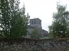
Kirche Saint-Pierre
Literatur
- Le Patrimoine des Communes de la Charente-Maritime. Flohic Editions, Band 2, Paris 2002, ISBN 2-84234-129-5, S. 1121–1122.
Weblinks
Commons: Lussant – Sammlung von Bildern, Videos und Audiodateien
This article is issued from Wikipedia. The text is licensed under Creative Commons - Attribution - Sharealike. The authors of the article are listed here. Additional terms may apply for the media files, click on images to show image meta data.