Le Grand-Village-Plage
| Le Grand-Village-Plage | ||
|---|---|---|
.svg.png.webp)
|
| |
| Staat | Frankreich | |
| Region | Nouvelle-Aquitaine | |
| Département (Nr.) | Charente-Maritime (17) | |
| Arrondissement | Rochefort | |
| Kanton | Île d’Oléron | |
| Gemeindeverband | Île d’Oléron | |
| Koordinaten | 45° 52′ N, 1° 14′ W | |
| Höhe | 2–22 m | |
| Fläche | 6,00 km² | |
| Einwohner | 1.070 (1. Januar 2019) | |
| Bevölkerungsdichte | 178 Einw./km² | |
| Postleitzahl | 17370 | |
| INSEE-Code | 17485 | |
| Website | https://www.legrandvillageplage.fr/ | |
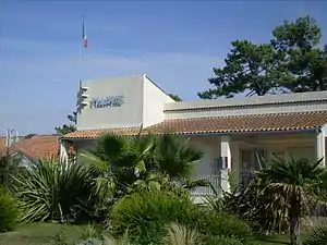 Rathaus (Mairie) von Le Grand-Village-Plage | ||

Le Grand-Village-Plage ist eine südwestfranzösische Gemeinde mit 1.070 Einwohnern (Stand: 1. Januar 2019) im Département Charente-Maritime in der Region Nouvelle-Aquitaine; sie gehört zum Arrondissement Rochefort und zum Kanton Île d’Oléron (bis 2015: Kanton Le Château-d’Oléron). Die Einwohner werden Grand-Villageois genannt.
Geographie
Le Grand-Village-Plage liegt am südwestlichen Rand der Île d’Oléron. Umgeben wird Le Grand-Village-Plage von den Nachbargemeinden Dolus-d’Oléron im Norden, Le Château-d’Oléron im Osten sowie Saint-Trojan-les-Bains im Süden.
Geschichte
1949 wurde Le Grand-Village-Plage aus Saint-Trojan-les-Bains herausgelöst.
Bevölkerungsentwicklung
| Jahr | 1962 | 1968 | 1975 | 1982 | 1990 | 1999 | 2008 | 2013 |
| Einwohner | 501 | 697 | 696 | 711 | 718 | 898 | 993 | 1.044 |
| Quelle: Cassini und INSEE | ||||||||
Sehenswürdigkeiten
- Kapelle Saint-Joseph
- Salzhafen
- Salzwiesen
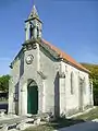 Kapelle Saint-Joseph
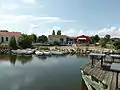 Salzhafen
Literatur
- Le Patrimoine des Communes de la Charente-Maritime. Flohic Editions, Band 1, Paris 2002, ISBN 2-84234-129-5, S. 192–193.
Weblinks
Commons: Le Grand-Village-Plage – Sammlung von Bildern, Videos und Audiodateien
This article is issued from Wikipedia. The text is licensed under Creative Commons - Attribution - Sharealike. The authors of the article are listed here. Additional terms may apply for the media files, click on images to show image meta data.