Saint-Marcelin-de-Cray
Saint-Marcelin-de-Cray ist eine französische Gemeinde mit 189 Einwohnern (Stand: 1. Januar 2019) im Département Saône-et-Loire in der Region Bourgogne-Franche-Comté (vor 2016 Bourgogne). Die Gemeinde gehört zum Arrondissement Mâcon und zum Kanton Cluny (bis 2015: Kanton La Guiche).
| Saint-Marcelin-de-Cray | ||
|---|---|---|
| ||
| Staat | Frankreich | |
| Region | Bourgogne-Franche-Comté | |
| Département (Nr.) | Saône-et-Loire (71) | |
| Arrondissement | Mâcon | |
| Kanton | Cluny | |
| Gemeindeverband | Clunisois | |
| Koordinaten | 46° 34′ N, 4° 32′ O | |
| Höhe | 218–445 m | |
| Fläche | 13,71 km² | |
| Einwohner | 189 (1. Januar 2019) | |
| Bevölkerungsdichte | 14 Einw./km² | |
| Postleitzahl | 71460 | |
| INSEE-Code | 71446 | |
| Website | https://www.saint-marcelin-de-cray.fr/ | |

Geografie
Saint-Marcelin-de-Cray liegt etwa 37 Kilometer nordwestlich von Mâcon und etwa 31 Kilometer südwestlich von Chalon-sur-Saône. Nachbargemeinden von Saint-Marcelin-de-Cray sind Mary im Norden, Saint-Martin-la-Patrouille im Osten und Nordosten, Sigy-le-Châtel im Südosten, Passy im Süden, Chevagny-sur-Guye im Süden und Südwesten sowie Le Rousset-Marizy im Westen.
Bevölkerungsentwicklung
| Jahr | 1962 | 1968 | 1975 | 1982 | 1990 | 1999 | 2006 | 2011 | 2016 |
| Einwohner | 242 | 206 | 178 | 160 | 164 | 140 | 138 | 185 | 184 |
| Quelle: Cassini und INSEE | |||||||||
Sehenswürdigkeiten
- Kirche Saint-Paul in Cray aus dem 11./12. Jahrhundert, Monument historique seit 1931
- Kirche Saint-Marcelin
- Großkreuz aus dem 13. Jahrhundert
- Mühle
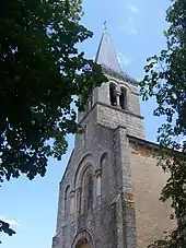
Kirche Saint-Marcelin
Weblinks
Commons: Saint-Marcelin-de-Cray – Sammlung von Bildern, Videos und Audiodateien
This article is issued from Wikipedia. The text is licensed under Creative Commons - Attribution - Sharealike. The authors of the article are listed here. Additional terms may apply for the media files, click on images to show image meta data.