Saint-Léger-sous-la-Bussière
Saint-Léger-sous-la-Bussière ist eine französische Gemeinde mit 279 Einwohnern (Stand: 1. Januar 2019) im Département Saône-et-Loire in der Region Bourgogne-Franche-Comté (vor 2016 Bourgogne). Sie gehört zum Arrondissement Mâcon und zum Kanton La Chapelle-de-Guinchay (bis 2015: Kanton Tramayes). Die Einwohner werden Saint Léodégariens genannt.
| Saint-Léger-sous-la-Bussière | ||
|---|---|---|
| ||
| Staat | Frankreich | |
| Region | Bourgogne-Franche-Comté | |
| Département (Nr.) | Saône-et-Loire (71) | |
| Arrondissement | Mâcon | |
| Kanton | La Chapelle-de-Guinchay | |
| Gemeindeverband | Saint-Cyr Mère Boitier entre Charolais et Mâconnais | |
| Koordinaten | 46° 19′ N, 4° 33′ O | |
| Höhe | 295–555 m | |
| Fläche | 8,59 km² | |
| Einwohner | 279 (1. Januar 2019) | |
| Bevölkerungsdichte | 32 Einw./km² | |
| Postleitzahl | 71520 | |
| INSEE-Code | 71441 | |
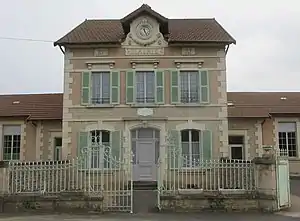 Rathaus (Mairie) von Saint-Léger-sous-la-Bussière | ||

Geographie
Saint-Léger-sous-la-Bussière liegt etwa 19 Kilometer westlich von Mâcon. Nachbargemeinden von Saint-Léger-sous-la-Bussière sind Trambly im Norden und Nordwesten, Navour-sur-Grosne im Norden, Tramayes im Osten, Deux-Grosnes im Süden, Saint-Pierre-le-Vieux im Südwesten sowie Matour im Westen.
Bevölkerungsentwicklung
| Jahr | 1962 | 1968 | 1975 | 1982 | 1990 | 1999 | 2006 | 2011 | 2016 |
| Einwohner | 347 | 328 | 297 | 278 | 276 | 256 | 265 | 254 | 261 |
| Quelle: Cassini und INSEE | |||||||||
Sehenswürdigkeiten
- Kirche Saint-Léger
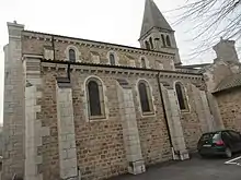
Kirche Saint-Léger
Weblinks
Commons: Saint-Léger-sous-la-Bussière – Sammlung von Bildern, Videos und Audiodateien
This article is issued from Wikipedia. The text is licensed under Creative Commons - Attribution - Sharealike. The authors of the article are listed here. Additional terms may apply for the media files, click on images to show image meta data.