Saint-Vérand (Saône-et-Loire)
Saint-Vérand ist eine französische Gemeinde mit 162 Einwohnern (Stand: 1. Januar 2019) im Département Saône-et-Loire in der Region Bourgogne-Franche-Comté. Die Gemeinde ist Teil des Arrondissements Mâcon und Teil des Kantons La Chapelle-de-Guinchay.
| Saint-Vérand | ||
|---|---|---|
.svg.png.webp)
|
| |
| Staat | Frankreich | |
| Region | Bourgogne-Franche-Comté | |
| Département (Nr.) | Saône-et-Loire (71) | |
| Arrondissement | Mâcon | |
| Kanton | La Chapelle-de-Guinchay | |
| Gemeindeverband | Mâconnais Beaujolais Agglomération | |
| Koordinaten | 46° 15′ N, 4° 44′ O | |
| Höhe | 220–475 m | |
| Fläche | 2,47 km² | |
| Einwohner | 162 (1. Januar 2019) | |
| Bevölkerungsdichte | 66 Einw./km² | |
| Postleitzahl | 71570 | |
| INSEE-Code | 71487 | |
| Website | http://www.saintverand.fr/ | |
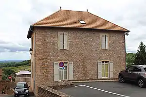 Rathaus (Mairie) von Saint-Vérand | ||

Geografie
Saint-Vérand liegt in der Landschaft Beaujolais, im Weinbaugebiet Bourgogne; hier wird aus den Trauben vor allem der Crémant de Bourgogne produziert. Umgeben wird Saint-Vérand von den Nachbargemeinden Leynes im Norden, Chânes im Osten und Südosten, Saint-Amour-Bellevue im Süden sowie Pruzilly im Westen.
Bevölkerungsentwicklung
| Jahr | 1962 | 1968 | 1975 | 1982 | 1990 | 1999 | 2006 | 2011 | 2016 |
|---|---|---|---|---|---|---|---|---|---|
| Einwohner | 169 | 165 | 146 | 181 | 191 | 182 | 183 | 176 | 167 |
| Quelle: Cassini und INSEE | |||||||||
Sehenswürdigkeiten
- Kirche Saint-Véran
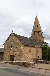
Kirche Saint-Véran
Weblinks
Commons: Saint-Vérand – Sammlung von Bildern, Videos und Audiodateien
This article is issued from Wikipedia. The text is licensed under Creative Commons - Attribution - Sharealike. The authors of the article are listed here. Additional terms may apply for the media files, click on images to show image meta data.