La Chapelle-du-Mont-de-France
La Chapelle-du-Mont-de-France ist eine französische Gemeinde mit 189 Einwohnern (Stand: 1. Januar 2019) im Département Saône-et-Loire in der Region Bourgogne-Franche-Comté (vor 2016 Bourgogne). Sie gehört zum Arrondissement Mâcon und zum Kanton La Chapelle-de-Guinchay (bis 2015: Kanton Tramayes). Die Einwohner werden Chapelois genannt.
| La Chapelle-du-Mont-de-France | ||
|---|---|---|
| ||
| Staat | Frankreich | |
| Region | Bourgogne-Franche-Comté | |
| Département (Nr.) | Saône-et-Loire (71) | |
| Arrondissement | Mâcon | |
| Kanton | La Chapelle-de-Guinchay | |
| Gemeindeverband | Saint-Cyr Mère Boitier entre Charolais et Mâconnais | |
| Koordinaten | 46° 23′ N, 4° 32′ O | |
| Höhe | 294–546 m | |
| Fläche | 9,14 km² | |
| Einwohner | 189 (1. Januar 2019) | |
| Bevölkerungsdichte | 21 Einw./km² | |
| Postleitzahl | 71520 | |
| INSEE-Code | 71091 | |
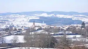 Blick auf La Chapelle-du-Mont-de-France | ||

Geographie
La Chapelle-du-Mont-de-France liegt etwa 19 Kilometer westnordwestlich von Mâcon. Nachbargemeinden von La Chapelle-du-Mont-de-France sind Curtil-sous-Buffières im Norden und Nordwesten, Bergesserin im Norden und Osten, Navour-sur-Grosne im Süden und Osten, Dompierre-les-Ormes im Westen und Südwesten sowie Trivy im Westen und Südwesten.
Durch die Gemeinde führt die Route nationale 79.
Bevölkerungsentwicklung
| Jahr | 1962 | 1968 | 1975 | 1982 | 1990 | 1999 | 2006 | 2011 | 2016 |
| Einwohner | 245 | 208 | 188 | 171 | 175 | 172 | 167 | 254 | 187 |
| Quelle: Cassini und INSEE | |||||||||
Sehenswürdigkeiten
- romanische Kirche Saint-Vincent aus dem 12. Jahrhundert
Weblinks
Commons: La Chapelle-du-Mont-de-France – Sammlung von Bildern, Videos und Audiodateien
This article is issued from Wikipedia. The text is licensed under Creative Commons - Attribution - Sharealike. The authors of the article are listed here. Additional terms may apply for the media files, click on images to show image meta data.