Sologny
Sologny ist eine französische Gemeinde mit 576 Einwohnern (Stand: 1. Januar 2019) im Département Saône-et-Loire in der Region Bourgogne-Franche-Comté. Sie gehört zum Arrondissement Mâcon und zum Kanton Hurigny (bis 2015: Kanton Mâcon-Nord). Die Einwohner werden Slonirons genannt.
| Sologny | ||
|---|---|---|
| ||
| Staat | Frankreich | |
| Region | Bourgogne-Franche-Comté | |
| Département (Nr.) | Saône-et-Loire (71) | |
| Arrondissement | Mâcon | |
| Kanton | Hurigny | |
| Gemeindeverband | Mâconnais Beaujolais Agglomération | |
| Koordinaten | 46° 22′ N, 4° 41′ O | |
| Höhe | 260–602 m | |
| Fläche | 10,69 km² | |
| Einwohner | 576 (1. Januar 2019) | |
| Bevölkerungsdichte | 54 Einw./km² | |
| Postleitzahl | 71960 | |
| INSEE-Code | 71525 | |
| Website | https://www.sologny.fr/ | |
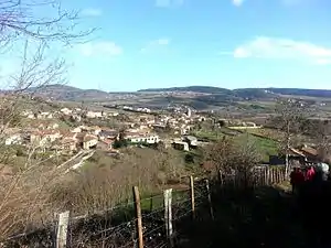 Blick auf Sologny | ||

Geographie
Sologny liegt etwa elf Kilometer östlich vom Stadtzentrum von Mâcon in der Mâconnais im Weinbaugebiet Bourgogne. Umgeben wird Sologny von den Nachbargemeinden Cluny im Norden, Berzé-la-Châtel im Nordosten, Berzé-la-Ville im Osten, Milly-Lamartine im Südosten, Pierreclos im Süden, Bourgvilain im Westen sowie Saint-Cécile im Nordwesten.
Durch die Gemeinde führt die Route nationale 79.
Bevölkerungsentwicklung
| Jahr | 1962 | 1968 | 1975 | 1982 | 1990 | 1999 | 2006 | 2013 |
|---|---|---|---|---|---|---|---|---|
| Einwohner | 361 | 386 | 350 | 352 | 394 | 458 | 447 | 576 |
| Quelle: Cassini und INSEE | ||||||||
Sehenswürdigkeiten
- Kirche Saint-Vincent aus dem 11./12. Jahrhundert, Monument historique
- Schloss Byonne
- Schloss Charnay
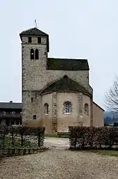
Kirche Saint-Vincent
Weblinks
Commons: Sologny – Sammlung von Bildern, Videos und Audiodateien
This article is issued from Wikipedia. The text is licensed under Creative Commons - Attribution - Sharealike. The authors of the article are listed here. Additional terms may apply for the media files, click on images to show image meta data.