Lacrost
Lacrost ist eine französische Gemeinde mit 710 Einwohnern (Stand: 1. Januar 2019) im Département Saône-et-Loire in der Region Bourgogne-Franche-Comté. Sie gehört zum Arrondissement Mâcon und zum Kanton Tournus. Lacrost ist Mitglied im Gemeindeverband Communauté de communes Mâconnais-Tournugeois.
| Lacrost | ||
|---|---|---|
| ||
| Staat | Frankreich | |
| Region | Bourgogne-Franche-Comté | |
| Département (Nr.) | Saône-et-Loire (71) | |
| Arrondissement | Mâcon | |
| Kanton | Tournus | |
| Gemeindeverband | Mâconnais-Tournugeois | |
| Koordinaten | 46° 33′ N, 4° 56′ O | |
| Höhe | 168–212 m | |
| Fläche | 10,46 km² | |
| Einwohner | 710 (1. Januar 2019) | |
| Bevölkerungsdichte | 68 Einw./km² | |
| Postleitzahl | 71700 | |
| INSEE-Code | 71248 | |

Geographie
Lacrost liegt etwa 27 Kilometer nordnordöstlich von Mâcon und etwa 36 Kilometer südsüdöstlich von Chalon-sur-Saône im Weinbaugebiet Bourgogne an der Saône. Umgeben wird Lacrost von den Nachbargemeinden Simandre im Norden und Nordosten, L’Abergement-de-Cuisery im Osten und Südosten, Préty im Süden sowie Tournus im Westen.
Bevölkerungsentwicklung
| Jahr | 1962 | 1968 | 1975 | 1982 | 1990 | 1999 | 2006 | 2011 | 2016 |
|---|---|---|---|---|---|---|---|---|---|
| Einwohner | 584 | 555 | 594 | 593 | 594 | 598 | 570 | 694 | 726 |
| Quelle: Cassini und INSEE | |||||||||
Sehenswürdigkeiten
- Nekropole von Les Prés-de-l’Eau, Monument historique seit 1934
- Kirche Sainte-Cécile
- Brunnen
- Schloss Grenod, Gebäude aus dem 16./17. Jahrhundert, Monument historique seit 1976
_harvested.jpg.webp) Feld über der Nekropole (Tumulus) von Les Prés-de-l’Eau
Feld über der Nekropole (Tumulus) von Les Prés-de-l’Eau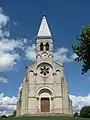 Kirche Sainte-Cécile
Weblinks
Commons: Lacrost – Sammlung von Bildern, Videos und Audiodateien
This article is issued from Wikipedia. The text is licensed under Creative Commons - Attribution - Sharealike. The authors of the article are listed here. Additional terms may apply for the media files, click on images to show image meta data.