Saint-Mamet
Saint-Mamet (Okzitanisch: Sent Memet) ist eine französische Gemeinde mit 555 Einwohnern (Stand: 1. Januar 2019) im Département Haute-Garonne in der Region Okzitanien; sie gehört zum Arrondissement Saint-Gaudens und zum 2016 gegründeten Gemeindeverband Pyrénées Haut Garonnaises. Die Einwohner werden Saint-Mametois genannt.
| Saint-Mamet Sent Memet | ||
|---|---|---|
| ||
| Staat | Frankreich | |
| Region | Okzitanien | |
| Département (Nr.) | Haute-Garonne (31) | |
| Arrondissement | Saint-Gaudens | |
| Kanton | Bagnères-de-Luchon | |
| Gemeindeverband | Pyrénées Haut Garonnaises | |
| Koordinaten | 42° 47′ N, 0° 36′ O | |
| Höhe | 630–1975 m | |
| Fläche | 11,29 km² | |
| Einwohner | 555 (1. Januar 2019) | |
| Bevölkerungsdichte | 49 Einw./km² | |
| Postleitzahl | 31110 | |
| INSEE-Code | 31500 | |
| Website | http://www.saint-mamet31.fr/ | |

Geografie
Saint-Mamet liegt am rechten Ufer des Pique in den Pyrenäen und in der historischen Provinz Comminges an der Grenze zu Spanien. Umgeben wird Saint-Mamet von den Nachbargemeinden Montauban-de-Luchon im Norden, Bossòst (Spanien) im Osten sowie Bagnères-de-Luchon im Süden und Westen.
Bevölkerungsentwicklung
| Jahr | 1962 | 1968 | 1975 | 1982 | 1990 | 1999 | 2006 | 2011 | 2016 |
| Einwohner | 365 | 392 | 410 | 442 | 491 | 499 | 525 | 557 | 545 |
| Quelle: Annuaire-mairie[1] und INSEE[2] | |||||||||
Sehenswürdigkeiten
- Kirche Saint-Mamet
- Wasserfall von Sidonie
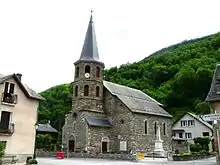
Kirche Saint-Mamet
This article is issued from Wikipedia. The text is licensed under Creative Commons - Attribution - Sharealike. The authors of the article are listed here. Additional terms may apply for the media files, click on images to show image meta data.