Gourdan-Polignan
Gourdan-Polignan ist eine Gemeinde im Département Haute-Garonne der Region Okzitanien in der Region Okzitanien im Süd-Westen Frankreichs.
| Gourdan-Polignan | ||
|---|---|---|

|
| |
| Staat | Frankreich | |
| Region | Okzitanien | |
| Département (Nr.) | Haute-Garonne (31) | |
| Arrondissement | Saint-Gaudens | |
| Kanton | Bagnères-de-Luchon | |
| Gemeindeverband | Pyrénées Haut Garonnaises | |
| Koordinaten | 43° 4′ N, 0° 34′ O | |
| Höhe | 411–635 m | |
| Fläche | 5,28 km² | |
| Einwohner | 1.203 (1. Januar 2019) | |
| Bevölkerungsdichte | 228 Einw./km² | |
| Postleitzahl | 31210 | |
| INSEE-Code | 31224 | |
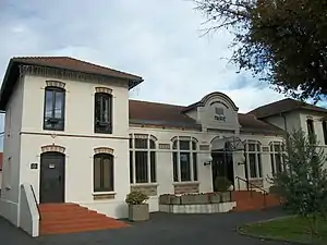
 Mairie Gourdan-Polignan | ||
Die an der Garonne gelegene Gemeinde entstand aus den Ortsteilen Gourdan und Polignan. Gourdan-Polignan hat 1203 Einwohner (Stand 1. Januar 2019).
Bevölkerungsentwicklung
| Jahr | 1962 | 1968 | 1975 | 1982 | 1990 | 1999 | 2006 | 2011 | 2017 |
|---|---|---|---|---|---|---|---|---|---|
| Einwohner | 1531 | 1664 | 1656 | 1394 | 1221 | 1194 | 1331 | 1333 | 1203 |
| Quellen: Cassini und INSEE | |||||||||
Sehenswürdigkeiten

Kirche Saint-Vincent
- Kirche Saint-Vincent
Siehe auch: Liste der Monuments historiques in Gourdan-Polignan
Verkehr
Gourdan-Polignan liegt südlich der Autoroute A64 (Europastraße 80) und westlich der Autoroute A645. Durch die Gemeinde führt die Route nationale 117. Mit der Gemeinde Montréjeau hat Gourdan-Polignan den Bahnhof Montréjeau-Gourdan-Polignan an der Bahnstrecke Toulouse – Bayonne.
Literatur
- Le Patrimoine des Communes de la Haute-Garonne. Flohic Editions, Band 1, Paris 2000, ISBN 2-84234-081-7, S. 318–321.
Weblinks
Commons: Gourdan-Polignan – Sammlung von Bildern, Videos und Audiodateien
- Bürgermeisterei von Gourdan-Polignan (französisch)
- Gourdan-Polignan (französisch)
This article is issued from Wikipedia. The text is licensed under Creative Commons - Attribution - Sharealike. The authors of the article are listed here. Additional terms may apply for the media files, click on images to show image meta data.
