Nénigan
Nénigan ist eine französische Gemeinde mit 56 Einwohnern (Stand 1. Januar 2019) im Département Haute-Garonne in der Region Okzitanien (zuvor Midi-Pyrénées). Die Einwohner werden als Néniganais bezeichnet.
| Nénigan | ||
|---|---|---|
| ||
| Staat | Frankreich | |
| Region | Okzitanien | |
| Département (Nr.) | Haute-Garonne (31) | |
| Arrondissement | Saint-Gaudens | |
| Kanton | Saint-Gaudens | |
| Gemeindeverband | Communauté de communes Cœur et Coteaux du Comminges | |
| Koordinaten | 43° 21′ N, 0° 42′ O | |
| Höhe | 213–297 m | |
| Fläche | 2,33 km² | |
| Einwohner | 56 (1. Januar 2019) | |
| Bevölkerungsdichte | 24 Einw./km² | |
| Postleitzahl | 31350 | |
| INSEE-Code | 31397 | |
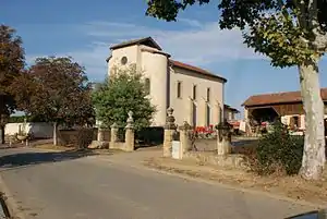 Kirche | ||

Geographie
Umgeben wird Nénigan von den vier Nachbargemeinden:
| Sarcos | Puymaurin | |
| Saint-Blancard | .svg.png.webp) |
Saint-Ferréol-de-Comminges |
| Péguilhan |
Bevölkerungsentwicklung
| Jahr | 1962 | 1968 | 1975 | 1982 | 1990 | 1999 | 2005 | 2010 | 2016 |
|---|---|---|---|---|---|---|---|---|---|
| Einwohner | 63 | 64 | 61 | 59 | 59 | 55 | 56 | 60 | 64 |
| Quelle: Cassini und INSEE | |||||||||
Sehenswürdigkeiten
- Kirche Saint-Christophe
- Ehemalige Mühle
Literatur
- Le Patrimoine des Communes de la Haute-Garonne. Flohic Editions, Band 1, Paris 2000, ISBN 2-84234-081-7, S. 390.
This article is issued from Wikipedia. The text is licensed under Creative Commons - Attribution - Sharealike. The authors of the article are listed here. Additional terms may apply for the media files, click on images to show image meta data.