Québriac
| Québriac Kevrieg | ||
|---|---|---|
.svg.png.webp)
|
| |
| Staat | Frankreich | |
| Region | Bretagne | |
| Département (Nr.) | Ille-et-Vilaine (35) | |
| Arrondissement | Saint-Malo | |
| Kanton | Combourg | |
| Gemeindeverband | Bretagne Romantique | |
| Koordinaten | 48° 21′ N, 1° 50′ W | |
| Höhe | 22–96 m | |
| Fläche | 20,79 km² | |
| Einwohner | 1.578 (1. Januar 2019) | |
| Bevölkerungsdichte | 76 Einw./km² | |
| Postleitzahl | 35440 | |
| INSEE-Code | 35233 | |
| Website | http://www.quebriac.fr/ | |

Québriac (bretonisch: Kevrieg; Gallo: Cóberiac) ist eine französische Gemeinde mit 1.578 Einwohnern (Stand: 1. Januar 2019) im Département Ille-et-Vilaine in der Region Bretagne; sie gehört zum Arrondissement Saint-Malo und zum Kanton Combourg (bis 2015: Kanton Hédé-Bazouges). Die Einwohner werden Québriacois genannt.
Geographie
Québriac liegt etwa 28 Kilometer nordnordwestlich von Rennes am Canal d’Ille-et-Rance. Umgeben wird Québriac von den Nachbargemeinden La Chapelle-aux-Filtzméens im Norden, Combourg im Nordosten, Dingé im Osten, Tinténiac im Süden sowie Saint-Domineuc im Westen.
Bevölkerungsentwicklung
| Jahr | 1962 | 1968 | 1975 | 1982 | 1990 | 1999 | 2006 | 2013 |
| Einwohner | 822 | 794 | 686 | 837 | 888 | 1.040 | 1.336 | 1.553 |
| Quelle: Cassini und INSEE | ||||||||
Sehenswürdigkeiten
Siehe auch: Liste der Monuments historiques in Québriac
- Kirche Saint-Pierre aus dem 12./13. Jahrhundert
- Schloss Québriac, Ende des 19. Jahrhunderts erbaut
- Herrenhaus La Motte
- Wallburg von Tremagouët
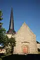 Kirche Saint-Pierre
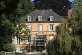 Schloss Québriac
Literatur
- Le Patrimoine des Communes d’Ille-et-Vilaine. Flohic Editions, Band 1, Paris 2000, ISBN 2-84234-072-8, S. 737–739.
This article is issued from Wikipedia. The text is licensed under Creative Commons - Attribution - Sharealike. The authors of the article are listed here. Additional terms may apply for the media files, click on images to show image meta data.