Municipio Tonatico
| Tonatico | ||
|---|---|---|
| Symbole | ||
| ||
| Basisdaten | ||
| Staat | Mexiko | |
| Bundesstaat | México | |
| Sitz | Tonatico | |
| Fläche | 91,7 km² | |
| Einwohner | 12.099 (2010) | |
| Dichte | 131,9 Einwohner pro km² | |
| Gründung | 1870 | |
| Webauftritt | www.tonatico.gob.mx/ | |
| INEGI-Nr. | 15107 | |
| Politik | ||
| Presidente municipal | Elodio Gordillo Méndez | |
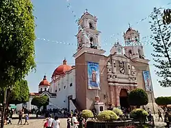
 Santuario de Nuestra Señora de Tonatico | ||
Tonatico ist ein Municipio im mexikanischen Bundesstaat México. Das Municipio hatte im Jahr 2010 12.099 Einwohner und 3.214 Haushalte; 11 % der Bevölkerung lebten in extremer Armut. Die Fläche des Municipios beträgt 91,7 km².
Verwaltungssitz und größter der 15 Orte des Municipios ist das gleichnamige Tonatico. Die nächstgrößeren Orte im Municipio sind El Terrero und La Puerta de Santiago.
Geographie
Tonatico liegt im Süden des Bundesstaates México, etwa 80 km südwestlich von Mexiko-Stadt, 50 km westlich von Cuernavaca und 50 km südlich von Toluca de Lerdo auf einer Höhe zwischen 1440 m und 2125 m.
Das Municipio Tonatico grenzt an die Municipios Ixtapan de la Sal und Zumpahuacán sowie an den Bundesstaat Guerrero.
Weblinks
Commons: Tonatico – Sammlung von Bildern, Videos und Audiodateien
- Enciclopedia de los Municipios y Delegaciones de México: Municipio Tonatico (spanisch)
- INEGI: Datos Geográficos: Municipio Tonatico (spanisch; PDF)
This article is issued from Wikipedia. The text is licensed under Creative Commons - Attribution - Sharealike. The authors of the article are listed here. Additional terms may apply for the media files, click on images to show image meta data.

