Municipio Papalotla
| Papalotla | ||
|---|---|---|
| Symbole | ||
| ||
| Basisdaten | ||
| Staat | Mexiko | |
| Bundesstaat | México | |
| Sitz | Papalotla | |
| Fläche | 3,2 km² | |
| Einwohner | 4147 (2010) | |
| Dichte | 1.303,7 Einwohner pro km² | |
| Gründung | 1827 | |
| Webauftritt | papalotlaedomex.gob.mx | |
| INEGI-Nr. | 15069 | |
| Politik | ||
| Presidente municipal | Isaac Mendarozo Buenfil | |
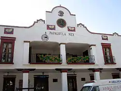
 Municipalpalast von Papalotla | ||
Papalotla ist ein Municipio im mexikanischen Bundesstaat México. Es gehört zur Zona Metropolitana del Valle de México, der Metropolregion um Mexiko-Stadt.
Die Gemeinde hatte im Jahr 2010 4.147 Einwohner, ihre Fläche beträgt 3,18 km². Das somit flächenmäßig kleinste Municipio des Bundesstaates umfasst laut INEGI-Statistik 2010 zwei Orte: den Hauptort Papalotla und den Weiler Mazatla.
Der Name Papalotla kommt aus dem Nahuatl: papalotl bedeutet „Schmetterling“ und -tlan bedeutet „Ort“, Papalotla also in etwa „Ort der Schmetterlinge“.
Geographie

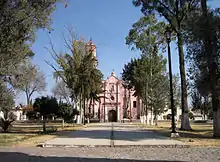
Kirche von Papalotla.
Papalotla liegt im Nordosten des Bundesstaates México, etwa 30 km nordöstlich von Mexiko-Stadt auf 2260 m Höhe.
Das Municipio Papalotla grenzt an die Municipios Chiautla, Tepetlaoxtoc und Texcoco.
Weblinks
Commons: Papalotla – Sammlung von Bildern, Videos und Audiodateien
- Enciclopedia de los Municipios y Delegaciones de México: Municipio Papalotla (spanisch)
- INEGI: Datos Geográficos: Municipio Papalotla (spanisch; PDF)
This article is issued from Wikipedia. The text is licensed under Creative Commons - Attribution - Sharealike. The authors of the article are listed here. Additional terms may apply for the media files, click on images to show image meta data.

