Municipio Hueypoxtla
| Hueypoxtla | ||
|---|---|---|
 | ||
| Symbole | ||
| ||
| Basisdaten | ||
| Staat | Mexiko | |
| Bundesstaat | México | |
| Sitz | Hueypoxtla | |
| Fläche | 235,2 km² | |
| Einwohner | 39.864 (2010) | |
| Dichte | 169,5 Einwohner pro km² | |
| Gründung | 29. November 1820 | |
| Webauftritt | www.hueypoxtla.gob.mx | |
| INEGI-Nr. | 15036 | |
| Politik | ||
| Presidente municipal | Francisco Santillán Santillán | |
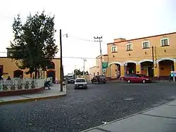 Ort Hueypoxtla | ||

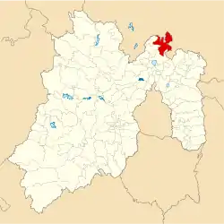
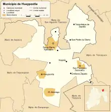
Hueypoxtla ist ein Municipio im mexikanischen Bundesstaat México. Es gehört zur Zona Metropolitana del Valle de México, der Metropolregion um Mexiko-Stadt. Der Sitz der Gemeinde ist das gleichnamige Hueypoxtla. Die Gemeinde hatte im Jahr 2010 39.864 Einwohner, ihre Fläche beträgt 235,2 km².
Geographie
Hueypoxtla liegt im Norden des Bundesstaates México, etwa 50 km nördlich von Mexiko-Stadt.
Das Municipio grenzt im Norden an Ajacuba und San Agustín Tlaxiaca im Bundesstaat Hidalgo, im Osten an Tolcayuca (Hidalgo), im Südosten an Tizayuca (Hidalgo), im Süden an Zumpango, im Westen an Tequixquiac und Apaxco (alle México).
Bevölkerung
Hueypoxtla zählte im Jahr 2010 39.864 Einwohner.
Größte Orte
| Städte | Einwohner |
| Gemeinde | 39.864 |
| Santa María Ajoloapan | 9.185 |
| San Marcos Jilotzingo | 8.523 |
| San Francisco Zacacalco | 7.420 |
| Hueypoxtla | 3.989 |
Weblinks
- Offizielle Website
- Enciclopedia de los Municipios y Delegaciones de México: Municipio Hueypoxtla (spanisch)
- INEGI: Datos Geográficos: Municipio Hueypoxtla (spanisch; PDF)

Acambay | Acolman | Aculco | Almoloya de Alquisiras | Almoloya de Juárez | Almoloya del Río | Amanalco | Amatepec | Amecameca | Apaxco | Atenco | Atizapán | Atizapán de Zaragoza | Atlacomulco | Atlautla | Axapusco | Ayapango | Calimaya | Capulhuac | Chalco | Chapa de Mota | Chapultepec | Chiautla | Chicoloapan | Chiconcuac | Chimalhuacán | Coacalco de Berriozábal | Coatepec Harinas | Cocotitlán | Coyotepec | Cuautitlán | Cuautitlán Izcalli | Donato Guerra | Ecatepec de Morelos | Ecatzingo | El Oro | Huehuetoca | Hueypoxtla | Huixquilucan | Isidro Fabela | Ixtapaluca | Ixtapan de la Sal | Ixtapan del Oro | Ixtlahuaca | Jaltenco | Jilotepec | Jilotzingo | Jiquipilco | Jocotitlán | Joquicingo | Juchitepec | La Paz | Lerma | Luvianos | Malinalco | Melchor Ocampo | Metepec | Mexicaltzingo | Morelos | Naucalpan de Juárez | Nextlalpan | Nezahualcóyotl | Nicolás Romero | Nopaltepec | Ocoyoacac | Ocuilan | Otumba | Otzoloapan | Otzolotepec | Ozumba | Papalotla | Polotitlán | Rayón | San Antonio la Isla | San Felipe del Progreso | San José del Rincón | San Martín de las Pirámides | San Mateo Atenco | San Simón de Guerrero | Santo Tomás | Soyaniquilpan de Juárez | Sultepec | Tecámac | Tejupilco | Temamatla | Temascalapa | Temascalcingo | Temascaltepec | Temoaya | Tenancingo | Tenango del Aire | Tenango del Valle | Teoloyucan | Teotihuacán | Tepetlaoxtoc | Tepetlixpa | Tepotzotlán | Tequixquiac | Texcaltitlán | Texcalyacac | Texcoco | Tezoyuca | Tianguistenco | Timilpan | Tlalmanalco | Tlalnepantla de Baz | Tlatlaya | Toluca | Tonanitla | Tonatico | Tultepec | Tultitlán | Valle de Bravo | Valle de Chalco Solidaridad | Villa de Allende | Villa del Carbón | Villa Guerrero | Villa Victoria | Xalatlaco | Xonacatlán | Zacazonapan | Zacualpan | Zinacantepec | Zumpahuacán | Zumpango